
IMAGES TAKEN NEAR TO
PE19 0AY
Introduction
This page details the photographs taken nearby to PE19 0AY by members of the Geograph project.
The Geograph project started in 2005 with the aim of publishing, organising and preserving representative images for every square kilometre of Great Britain, Ireland and the Isle of Man.

There are currently over 7.5m images from over14,400 individuals and you can help contribute to the project by visiting https://www.geograph.org.uk
Image Map
Images are licensed for reuse under creativecommons.org/licenses/by-sa/2.0
Notes
- Clicking on the map will re-center to the selected point.
- The higher the marker number, the further away the image location is from the centre of the postcode.
Image Listing (14 Images Found)
Images are licensed for reuse under creativecommons.org/licenses/by-sa/2.0
Image
Details
Distance
1

Crop field and power lines
Off the A428 near St Neots.
Image: © JThomas
Taken: 4 Jun 2015
0.11 miles

3

Harvesting
Harvest in progress opposite Loves Farm.
Image: © John Webber
Taken: 13 Aug 2009
0.14 miles
5

Footpath between two roads, St Neots
This footpath, through a section of new housing development that was still under construction at the time this picture was taken, appears to be sandwiched between Currington Avenue (left) and another new road which is labelled as Currington Avenue on Google Maps (right). Further to the right, there appears to be another footpath. Quite why thoroughfares in this development are being duplicated in this way is unknown to me; perhaps it is an inevitable result of housing developments being designed by developers as self contained entities.
Image: © Richard Vince
Taken: 14 Jan 2023
0.14 miles
6

Building site south of Currington Avenue, St Neots
More housing under construction adjacent to another as yet unfinished housing development.
Image: © Richard Vince
Taken: 14 Jan 2023
0.15 miles
7

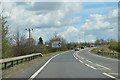
A428 heading south west
Heading towards the A1, by-passing St Neots.
Image: © JThomas
Taken: 4 Jun 2015
0.16 miles
8

Currington Avenue, St Neots
On the right is a short row of occupied houses surrounded by a massive building site.
Image: © Richard Vince
Taken: 14 Jan 2023
0.17 miles

10

St. Neots across the fields from the A428
Image: © Jeff Tomlinson
Taken: 3 Jun 2007
0.18 miles