IMAGES TAKEN NEAR TO
PE17 3TU
Introduction
This page details the photographs taken nearby to PE17 3TU by members of the Geograph project.
The Geograph project started in 2005 with the aim of publishing, organising and preserving representative images for every square kilometre of Great Britain, Ireland and the Isle of Man.

There are currently over 7.5m images from over14,400 individuals and you can help contribute to the project by visiting https://www.geograph.org.uk
Image Map
Images are licensed for reuse under creativecommons.org/licenses/by-sa/2.0
Notes
- Clicking on the map will re-center to the selected point.
- The higher the marker number, the further away the image location is from the centre of the postcode.
Image Listing (21 Images Found)
Images are licensed for reuse under creativecommons.org/licenses/by-sa/2.0
Image
Details
Distance
1
The Needingworth Fire Hooks
Two old fire hooks on display Needingworth, Cambridgeshire.
Image: © Keith Evans
Taken: 25 Aug 2009
0.09 miles
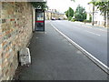
3
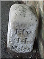
Ely 14 Miles
Old milestone on what was the A.1123 at Needingworth, Cambridgeshire. For overall view see http://www.geograph.org.uk/photo/1458116
Image: © Keith Evans
Taken: 25 Aug 2009
0.10 miles
5
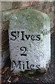
Old Milestone by High Street, Needingworth
Carved stone post by the UC road, in parish of HOLYWELL CUM NEEDINGWORTH (HUNTINGDONSHIRE District), Needingworth High Street, by No. 62, in pavement, on Southeast side of road. St Ives stone, erected by the Shelton Lane, Bury & Stratton turnpike trust in the 19th century.
Inscription reads:-
: St Ives / 2 / Miles : : Needingworth : : Ely / 14 / Miles :
Grade II listed.
List Entry Number: 1128421 https://historicengland.org.uk/listing/the-list/list-entry/1128421
Milestone Society National ID: HU_SIEY02.
Image: © MW Hallett
Taken: 8 Jan 2006
0.12 miles
6
Old Milestone
Old milestone on what was the A.1123 at Needingworth, Cambridgeshire. For close up view see http://www.geograph.org.uk/photo/1458113
Image: © Keith Evans
Taken: 25 Aug 2009
0.13 miles
8
Memorial and Lock-up, Needingworth
The lock up was built in 1838 and according to the listed building entry has a cat-slide tile roof (whatever that is)
Image: © Des Blenkinsopp
Taken: 30 Jun 2010
0.14 miles
9
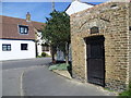
The Village Lock Up, Needingworth
The Village Lock Up, is found in the centre of Needingworth, at the junction of Overcote Lane and Needingworth High Street. It dates from 1838 as made clear by the sign over the door.
Image: © Marathon
Taken: 3 May 2013
0.14 miles
10
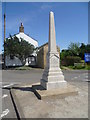
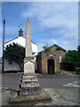
Needingworth War Memorial
The war memorial, is found in the centre of Needingworth, at the junction of Overcote Lane and Needingworth High Street. Just behind and hidden from view is the village lock up which dates from 1838 - see http://www.geograph.org.uk/photo/3445753
Image: © Marathon
Taken: 3 May 2013
0.15 miles