
IMAGES TAKEN NEAR TO
The Green, MARCH, PE15 8JD
Introduction
This page details the photographs taken nearby to The Green, PE15 8JD by members of the Geograph project.
The Geograph project started in 2005 with the aim of publishing, organising and preserving representative images for every square kilometre of Great Britain, Ireland and the Isle of Man.

There are currently over 7.5m images from over14,400 individuals and you can help contribute to the project by visiting https://www.geograph.org.uk
Image Map
Images are licensed for reuse under creativecommons.org/licenses/by-sa/2.0
Notes
- Clicking on the map will re-center to the selected point.
- The higher the marker number, the further away the image location is from the centre of the postcode.
Image Listing (29 Images Found)
Images are licensed for reuse under creativecommons.org/licenses/by-sa/2.0
Image
Details
Distance
1

Entrance to Nursery Drive, off Wisbech Road
Image: © dennis smith
Taken: 1 Feb 2008
0.03 miles

3

Post Office on the corners of Wisbech Road and Hillside Road
Image: © dennis smith
Taken: 1 Feb 2008
0.07 miles
4
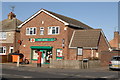
Post Office on the corners of Wisbech Road and Hillside Road
Image: © dennis smith
Taken: 1 Feb 2008
0.07 miles


7
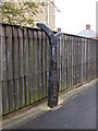
Millennium milepost on NCN 63
This post is on a 60 metre link between Truman Avenue and the Wisbech Road.
Inscribed: Whittlesey 11m - Wisbech 12m
See also Image
Image: © Keith Edkins
Taken: 16 Jun 2008
0.10 miles
8

Time plaque on Millennium milepost
This is the plaque on Image It represents the 13th century, hence the Magna Carta (1215) under the magnifying class. The rabbits form a Fibonacci sequence, recalling Fibonacci's publication of the Liber Abaci (1202) in which the sequence appears as the solution to a problem in rabbit population growth.
Image: © Keith Edkins
Taken: 16 Jun 2008
0.10 miles
9

Peas Hill Road, Leading to Elliott Road
Image: © dennis smith
Taken: 21 Jan 2008
0.11 miles
10

Entrance of Peas Hill Road, junction with Elliott Road
Image: © dennis smith
Taken: 1 Feb 2008
0.14 miles