
IMAGES TAKEN NEAR TO
West End, MARCH, PE15 8DB
Introduction
This page details the photographs taken nearby to West End, PE15 8DB by members of the Geograph project.
The Geograph project started in 2005 with the aim of publishing, organising and preserving representative images for every square kilometre of Great Britain, Ireland and the Isle of Man.

There are currently over 7.5m images from over14,400 individuals and you can help contribute to the project by visiting https://www.geograph.org.uk
Image Map
Images are licensed for reuse under creativecommons.org/licenses/by-sa/2.0
Notes
- Clicking on the map will re-center to the selected point.
- The higher the marker number, the further away the image location is from the centre of the postcode.
Image Listing (68 Images Found)
Images are licensed for reuse under creativecommons.org/licenses/by-sa/2.0
Image
Details
Distance

2

Entrance of Peas Hill Road, junction with Elliott Road
Image: © dennis smith
Taken: 1 Feb 2008
0.09 miles
3

Hereward Way outside March Marina
The long distance footpath skirts around the perimeter of March Marina, which is well concealed from public scrutiny by trees, fences and assorted vegetation.
Image: © Chris Heaton
Taken: 13 May 2025
0.10 miles

5

Time plaque on Millennium milepost 2
The plaque on Image is T5 14, ie the 14th century. It appears to feature a weight-driven clock mechanism - these were coming into general use in the early part of the century
Image: © Keith Edkins
Taken: 16 Jun 2008
0.12 miles
6
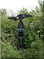
Millennium milepost 2 on NCN 63
I can't believe this is a whole mile from Image It is on a track which leads down to the river bank to pass under the Isle of Ely Way.
Inscribed Whittlesey 10m - March 1m
See also: Image
Image: © Keith Edkins
Taken: 16 Jun 2008
0.12 miles
7

Peas Hill Road, Leading to Elliott Road
Image: © dennis smith
Taken: 21 Jan 2008
0.12 miles


10

River Nene from under the Isle of Ely Way
Image: © Keith Edkins
Taken: 16 Jun 2008
0.14 miles