
IMAGES TAKEN NEAR TO
Smeeth Road, WISBECH, PE14 8ES
Introduction
This page details the photographs taken nearby to Smeeth Road, PE14 8ES by members of the Geograph project.
The Geograph project started in 2005 with the aim of publishing, organising and preserving representative images for every square kilometre of Great Britain, Ireland and the Isle of Man.

There are currently over 7.5m images from over14,400 individuals and you can help contribute to the project by visiting https://www.geograph.org.uk
Image Map
Images are licensed for reuse under creativecommons.org/licenses/by-sa/2.0
Notes
- Clicking on the map will re-center to the selected point.
- The higher the marker number, the further away the image location is from the centre of the postcode.
Image Listing (17 Images Found)
Images are licensed for reuse under creativecommons.org/licenses/by-sa/2.0
Image
Details
Distance
1

Marshland St. James Methodist Church
Image: © Jonathan Thacker
Taken: 11 Aug 2019
0.07 miles
2

Dismantled railway, Marshland St. James: aerial 2022
Image: © Chris
Taken: 19 Jul 2022
0.09 miles
3

The former Smeeth Road Station, Marshland St James.
The dismantled railway crossed the Smeeth Road here.
Image: © Dr Charles Nelson
Taken: 1 Nov 2005
0.15 miles
4

The former Smeeth Road Station
The station opened in 1848 and closed in 1968. Note the water tank attached to the station building.
Image: © Jonathan Thacker
Taken: 11 Aug 2019
0.15 miles
5

Former railway goods shed, Smeeth Road Station
Now converted to housing.
The railway opened in 1848 and closed in 1968.
Image: © Jonathan Thacker
Taken: 11 Aug 2019
0.17 miles
6

Former Primitive Methodist Chapel and Sunday School
Dated 1891.
Image: © Jonathan Thacker
Taken: 11 Aug 2019
0.19 miles
7

Village sign in Smeeth Road, Marshland St James
Image: © Adrian S Pye
Taken: 27 Jul 2015
0.20 miles

9

Prefabricated houses, School Road
Appear to be of the Swedish style.
Image: © Jonathan Thacker
Taken: 11 Aug 2019
0.20 miles
10
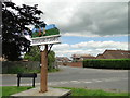
Marshland St. James village sign
This is the reverse. Here Tom talks to a tinker. The tinker is the one in red with the broom who challenged Tom to dancing with a broom, and beat him because Tom was too slow and clumsy.
On the front the man with the cart is Tom Hinkathrift who was a strong fellow and by removing a wheel from his cart to use as a shield and using the axle as a weapon beat the giant who was trying to steal the beer he was carting. He then found the cave (in the fens?) where the giant lived which was filled with gold. He proceeded to fill his cart with it and lived happily ever after. All nonsense with an element of truth as Tom Hinkathrift was an exceptionally strong and tall man who fought against oppression and created a legend for himself. He is buried at Tilney All Saints where he is also featured in the village sign.
https://www.geograph.org.uk/photo/6199605
Image: © Adrian S Pye
Taken: 2 Jul 2019
0.21 miles