
IMAGES TAKEN NEAR TO
South Brink, WISBECH, PE14 0RS
Introduction
This page details the photographs taken nearby to South Brink, PE14 0RS by members of the Geograph project.
The Geograph project started in 2005 with the aim of publishing, organising and preserving representative images for every square kilometre of Great Britain, Ireland and the Isle of Man.

There are currently over 7.5m images from over14,400 individuals and you can help contribute to the project by visiting https://www.geograph.org.uk
Image Map
Images are licensed for reuse under creativecommons.org/licenses/by-sa/2.0
Notes
- Clicking on the map will re-center to the selected point.
- The higher the marker number, the further away the image location is from the centre of the postcode.
Image Listing (13 Images Found)
Images are licensed for reuse under creativecommons.org/licenses/by-sa/2.0
Image
Details
Distance
1

The A47 south of Wisbech
The River Nene is behind the barrier
Image: © David Howard
Taken: 14 Nov 2019
0.03 miles


4

Unusual Sight.
A sight not often seen these days. A narrow boat on the tidal Nene approaching Wisbech.
Image: © Tony Bennett
Taken: 25 Jun 2012
0.06 miles
5

A47 South Brink towards Wisbech
The River Nene is beyond the crash barrier on the left.
Image: © Robin Webster
Taken: 12 Feb 2018
0.07 miles
6
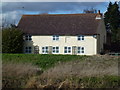
The Three Horseshoes - Public Houses, Inns and Taverns of Wisbech
This building was once The Three Horseshoes on North Brink, Wisbech overlooking the River Nene. It is marked on the 1903 Six Inch Ordnance Survey map as a beer house, see https://maps.nls.uk/geo/explore/#zoom=16.7&lat=52.64261&lon=0.12791&layers=6&b=1 There is a ferry crossing point shown on the map at this point also.
The photographers grandfather used to drink in this pub.
Image: © Richard Humphrey
Taken: 4 Mar 2016
0.08 miles

8

Fen Shovel
Dredging the Nene. Although very few boats use it these days.
Image: © Tony Bennett
Taken: 12 Nov 2008
0.10 miles
9

A47 at Broad Drove
As is common locally, the road uses an extended levee. Fields on the left are at a considerably lower level. The River Nene is immediately beyond the road.
Image: © Peter Whatley
Taken: 21 Apr 2010
0.12 miles
10

Nene Bank
Off the North Brink lane south-west of Wisbech.
Image: © Jonathan Billinger
Taken: 20 Dec 2006
0.14 miles