
IMAGES TAKEN NEAR TO
Cedar Way, WISBECH, PE14 0JJ
Introduction
This page details the photographs taken nearby to Cedar Way, PE14 0JJ by members of the Geograph project.
The Geograph project started in 2005 with the aim of publishing, organising and preserving representative images for every square kilometre of Great Britain, Ireland and the Isle of Man.

There are currently over 7.5m images from over14,400 individuals and you can help contribute to the project by visiting https://www.geograph.org.uk
Image Map
Images are licensed for reuse under creativecommons.org/licenses/by-sa/2.0
Notes
- Clicking on the map will re-center to the selected point.
- The higher the marker number, the further away the image location is from the centre of the postcode.
Image Listing (52 Images Found)
Images are licensed for reuse under creativecommons.org/licenses/by-sa/2.0
Image
Details
Distance

2

Geese by the roadside
A small flock of geese has settled down here for the afternoon. Presumably they go swimming in the nearby pond > http://www.geograph.org.uk/photo/1267453. The new housing seen in the background is called Grove Gardens.
Image: © Evelyn Simak
Taken: 22 Apr 2009
0.05 miles
3

Pond reflections
A new thatched house in Grove Gardens is reflected in the village pond which is home to a small flock of geese, presently resting nearby > http://www.geograph.org.uk/photo/1267446.
Image: © Evelyn Simak
Taken: 22 Apr 2009
0.08 miles
4

Aptly named
The Red House, fronted by a lovely display of spring flowers, is set back from Fridaybridge Road.
Image: © Evelyn Simak
Taken: 22 Apr 2009
0.08 miles
5

The Sportsman public house undergoing restoration
http://www.geograph.org.uk/photo/5660158
Image: © Adrian S Pye
Taken: 23 Jan 2018
0.08 miles
6

The war memorial in Elm
The war memorial is located on its own green just west of, and across Fridaybridge Road from All Saints church.
Image: © Evelyn Simak
Taken: 22 Apr 2009
0.09 miles
7

The Sportsman - pub sign
See > http://www.geograph.org.uk/photo/1267432 for a view of the pub. Fridaybridge Road leads past here.
Image: © Evelyn Simak
Taken: 22 Apr 2009
0.09 miles
8

The Sportsman
This public house is located beside Fridaybridge Road near All Saints church. See > http://www.geograph.org.uk/photo/1267430 for its pub sign.
Image: © Evelyn Simak
Taken: 22 Apr 2009
0.09 miles
9

Bridge to Grove Gardens
The bridge takes the cul-de-sac to new housing which is called Grove Gardens. A new thatched house can be seen in the background.
Image: © Evelyn Simak
Taken: 22 Apr 2009
0.10 miles
10
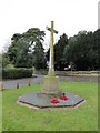
Elm War Memorial
The memorial bears the names of 39 men who fell in WW1 and a further ten who fell in the Second World War.
Image: © Adrian S Pye
Taken: 23 Jan 2018
0.10 miles