
IMAGES TAKEN NEAR TO
New Bridge Lane, PE14 0EY
Introduction
This page details the photographs taken nearby to New Bridge Lane, PE14 0EY by members of the Geograph project.
The Geograph project started in 2005 with the aim of publishing, organising and preserving representative images for every square kilometre of Great Britain, Ireland and the Isle of Man.

There are currently over 7.5m images from over14,400 individuals and you can help contribute to the project by visiting https://www.geograph.org.uk
Image Map
Images are licensed for reuse under creativecommons.org/licenses/by-sa/2.0
Notes
- Clicking on the map will re-center to the selected point.
- The higher the marker number, the further away the image location is from the centre of the postcode.
Image Listing (7 Images Found)
Images are licensed for reuse under creativecommons.org/licenses/by-sa/2.0
Image
Details
Distance

2

New Bridge Lane, Wisbech
Looking towards the A47
Image: © David Howard
Taken: 14 Nov 2019
0.10 miles
3

New Culvert
New culvert has been cut to make easier access to the construction in the background.
Image: © Tony Bennett
Taken: 3 Jun 2009
0.14 miles
4

Lineage Logistics warehouse by the A47, Wisbech
It is a cold store, the building is on Boleness Road alongside the A47 https://www.lineagelogistics.com/facilities/wisbech-boleness
Image: © David Howard
Taken: 14 Nov 2019
0.17 miles
5
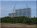
New Landmark
What was once a clear view. Is gone forever.
Image: © Tony Bennett
Taken: 3 Jun 2009
0.20 miles
6

Ambulance on the Wisbech by-pass (A47)
The recently completed giant cold store merges into the clouds behind the ambulance http://www.geograph.org.uk/photo/1975644
Image: © Richard Humphrey
Taken: 28 Jul 2010
0.20 miles
7
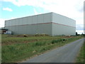
Giant cold store in Wisbech
A view from New Bridge Lane of the rear of this cold store which was opened in June 2010
Image: © Richard Humphrey
Taken: 23 Jul 2010
0.22 miles