
IMAGES TAKEN NEAR TO
High Road, WISBECH, PE13 5HW
Introduction
This page details the photographs taken nearby to High Road, PE13 5HW by members of the Geograph project.
The Geograph project started in 2005 with the aim of publishing, organising and preserving representative images for every square kilometre of Great Britain, Ireland and the Isle of Man.

There are currently over 7.5m images from over14,400 individuals and you can help contribute to the project by visiting https://www.geograph.org.uk
Image Map
Images are licensed for reuse under creativecommons.org/licenses/by-sa/2.0
Notes
- Clicking on the map will re-center to the selected point.
- The higher the marker number, the further away the image location is from the centre of the postcode.
Image Listing (15 Images Found)
Images are licensed for reuse under creativecommons.org/licenses/by-sa/2.0
Image
Details
Distance
1

Newton in the Isle village sign
The village is more usually simply known as Newton.
Image: © Adrian S Pye
Taken: 6 Jan 2011
0.01 miles

3

Entrance to Newton in the Isle
Only referred to as 'Newton' on the OS map. With hardly any evident elevation, it is difficult to imagine it as an 'isle'; the 'isle' apparently refers to the Isle of Ely http://www.newtonintheisle.org.uk/history.php
Image: © Tim Heaton
Taken: 25 Nov 2016
0.03 miles
4

Newton in the Isle
Newton village sign on High Road. Newton in the Isle (of Ely) differentiating it from the other Newton near Cambridge
Image: © Richard Croft
Taken: 9 Aug 2012
0.03 miles
5

Newton in the Isle village street and sign
The village sign can be seen on the left of the picture and enlarged here > Image
Image: © Adrian S Pye
Taken: 6 Jan 2011
0.04 miles
6
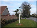
Village sign, Newton in the Isle
The village lies on a dry strip of land called the silt fen. This land would have been dry before the drainage of the fens from C17 onwards, hence the name Isle. See http://www.geograph.org.uk/photo/4445482 for a close up.
Image: © Bikeboy
Taken: 14 Apr 2015
0.06 miles
7
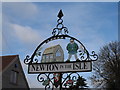
Village sign, Newton in the Isle (close-up)
The village lies on a dry strip of land called the silt fen. This land would have been dry before the drainage of the fens from C17 onwards, hence the name Isle.
Image: © Bikeboy
Taken: 14 Apr 2015
0.06 miles
8

Newton Hall
The entrance to Newton Hall with a cattle grid preventing the Highland cattle from wandering.
Image: © Michael Patterson
Taken: 18 May 2006
0.10 miles
9

Dead and alive
A dead tree on Brewer's Lane Newton smothered with ivy
Image: © Richard Humphrey
Taken: 22 Oct 2009
0.16 miles
