
IMAGES TAKEN NEAR TO
High Side, WISBECH, PE13 4SA
Introduction
This page details the photographs taken nearby to High Side, PE13 4SA by members of the Geograph project.
The Geograph project started in 2005 with the aim of publishing, organising and preserving representative images for every square kilometre of Great Britain, Ireland and the Isle of Man.

There are currently over 7.5m images from over14,400 individuals and you can help contribute to the project by visiting https://www.geograph.org.uk
Image Map
Images are licensed for reuse under creativecommons.org/licenses/by-sa/2.0
Notes
- Clicking on the map will re-center to the selected point.
- The higher the marker number, the further away the image location is from the centre of the postcode.
Image Listing (14 Images Found)
Images are licensed for reuse under creativecommons.org/licenses/by-sa/2.0
Image
Details
Distance

2

Bellamy's Bridge, Cambridgeshire
The bridge is out of shot to the right where Sand Bank goes over White Engine Drain.
Image: © David Prestidge
Taken: 2 Jun 2006
0.02 miles
3

2.77 acres of winter wheat at Bellamy's Bridge, Wisbech St Mary
A view along Highside with the houses of Garden Lane in the distance.
Just in shot on the right hand side a new bungalow (Long Acre Garden Centre) now stands on the site of an old timber bungalow where the photographer lived until the age of 5. The end of the old bungalow can be seen in this photo http://www.geograph.org.uk/photo/3614004
Image: © Richard Humphrey
Taken: 6 Oct 2011
0.03 miles
4

Crop field, Bellamy's Bridge
East of the B1166.
Image: © JThomas
Taken: 17 May 2014
0.03 miles

6

Road junction taken from outside Long Acre garden centre
Image: © Adrian S Pye
Taken: 9 Jan 2011
0.04 miles
7

Sheep and lambs - Seadyke Farm, Wisbech St Mary
Reg Humphrey (1902-1989), my grandfather, kept sheep on this grass field for over 50 years. The row of houses are still standing on Garden Lane but this view does not exist anymore. The wooden bungalow has been replaced with a brick one and a large garden centre has been built on the field, (Long Acre Garden Centre) see http://www.geograph.org.uk/photo/2226093
Image: © The Humphrey family archive
Taken: Unknown
0.09 miles
8

Road past a plant nursery by Bellamy's Bridge
Image: © Evelyn Simak
Taken: 9 Jan 2011
0.11 miles
9

Feeding the sheep - Seadyke Farm, Wisbech St Mary
Sheep owned by my grandfather, Reg Humphrey (1902-1989) being fed by his stockman and farm hand Johnny (Iwan) Mazur. I think Mr Mazur (d.19th January 1990) was a Ukrainian POW who settled in the area after the war??
Image: © The Humphrey family archive
Taken: 1 Apr 1976
0.11 miles
10
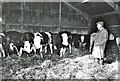
Checking his bullocks at Seadyke Farm
Reg Humphrey (1902-1989) checking his cattle at his farm near Wisbech St Mary. He was a well known sheep/cattle dealer at many of the local livestock markets in Cambridgeshire, Lincs and Norfolk most of which have now closed. Until supermarkets evolved in the mid-20th century, livestock markets were the key trading arenas for farmers, dealers and butchers, and important social gatherings for the farming community. Deals were often made in nearby public houses after the markets had finished. Before the days of 24/7 opening hours pubs near markets were allowed to open longer hours to cater for the needs of people at the market.
Image: © The Humphrey family archive
Taken: 1 Apr 1976
0.13 miles