IMAGES TAKEN NEAR TO
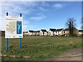
Cotterell Way, WISBECH, PE13 3BL
Introduction
This page details the photographs taken nearby to Cotterell Way, PE13 3BL by members of the Geograph project.
The Geograph project started in 2005 with the aim of publishing, organising and preserving representative images for every square kilometre of Great Britain, Ireland and the Isle of Man.

There are currently over 7.5m images from over14,400 individuals and you can help contribute to the project by visiting https://www.geograph.org.uk
Image Map
Images are licensed for reuse under creativecommons.org/licenses/by-sa/2.0
Notes
- Clicking on the map will re-center to the selected point.
- The higher the marker number, the further away the image location is from the centre of the postcode.
Image Listing (207 Images Found)
Images are licensed for reuse under creativecommons.org/licenses/by-sa/2.0
Image
Details
Distance
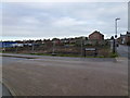
1
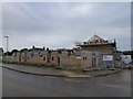
Nene Waterfront regeneration, Wisbech - No 8
This is part of a large area on the side of The River Nene which was razed to the ground years ago and has been overgrown ever since. At long last work on the construction of new housing has recently started.
The site was previously occupied by the town's gasworks, a grain handling facility, light industry, a nightclub and Victorian housing
Image: © Richard Humphrey
Taken: 13 Nov 2015
0.01 miles
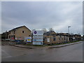
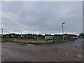
2
Nene Waterfront regeneration, Wisbech - No 10
At the junction of Cotterell Way and De Havilland Road
This is part of a large area on the side of The River Nene which was razed to the ground years ago and has been overgrown ever since. At long last work on the construction of new housing has recently started.
The site was previously occupied by the town's gasworks, a grain handling facility, light industry, a nightclub and Victorian housing
Image: © Richard Humphrey
Taken: 13 Nov 2015
0.01 miles
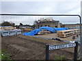
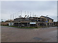
3
Nene Waterfront regeneration, Wisbech - No 7
On Cotterell Way
This is part of a large area on the side of The River Nene which was razed to the ground years ago and has been overgrown ever since. At long last work on the construction of new housing has recently started.
The site was previously occupied by the town's gasworks, a grain handling facility, light industry, a nightclub and Victorian housing
Image: © Richard Humphrey
Taken: 13 Nov 2015
0.02 miles
4
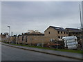
Nene Waterfront regeneration, Wisbech - No 6
On Cotterell Way.
This is part of a large area on the side of The River Nene which was razed to the ground years ago and has been overgrown ever since. At long last work on the construction of new housing has recently started.
The site was previously occupied by the town's gasworks, a grain handling facility, light industry, a nightclub and Victorian housing
Image: © Richard Humphrey
Taken: 13 Nov 2015
0.02 miles
5
Nene Waterfront regeneration, Wisbech - No 9
At the junction of Cotterell Way and De Havilland Road
This is part of a large area on the side of The River Nene which was razed to the ground years ago and has been overgrown ever since. At long last work on the construction of new housing has recently started.
The site was previously occupied by the town's gasworks, a grain handling facility, light industry, a nightclub and Victorian housing
Image: © Richard Humphrey
Taken: 13 Nov 2015
0.03 miles
6
Nene Waterfront regeneration, Wisbech - No 5
At the junction of Cotterell Way and Chase Street
This is part of a large area on the side of The River Nene which was razed to the ground years ago and has been overgrown ever since. At long last work on the construction of new housing has recently started.
The site was previously occupied by the town's gasworks, a grain handling facility, light industry, a nightclub and Victorian housing
Image: © Richard Humphrey
Taken: 13 Nov 2015
0.04 miles
7
Nene Waterfront regeneration, Wisbech - No 4
At the junction of Chase Street and Cotterell Way.
This is part of a large area on the side of The River Nene which was razed to the ground years ago and has been overgrown ever since. At long last work on the construction of new housing has recently started.
The site was previously occupied by the town's gasworks, a grain handling facility, light industry, a nightclub and Victorian housing
Image: © Richard Humphrey
Taken: 13 Nov 2015
0.04 miles
8
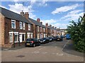
Opportune Road, Wisbech
A row of semi-detached houses
Image: © Eirian Evans
Taken: 24 Jul 2022
0.04 miles
9
Nene Waterfront regeneration site in Wisbech
Image: © Richard Humphrey
Taken: 21 Mar 2020
0.07 miles
10
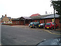
Clarkson Surgery, De Havilland Road, Wisbech
Built on the site of the old hospital.
Image: © Dr Charles Nelson
Taken: 26 Oct 2005
0.07 miles