
IMAGES TAKEN NEAR TO
Cromwell Road, WISBECH, PE13 2RG
Introduction
This page details the photographs taken nearby to Cromwell Road, PE13 2RG by members of the Geograph project.
The Geograph project started in 2005 with the aim of publishing, organising and preserving representative images for every square kilometre of Great Britain, Ireland and the Isle of Man.

There are currently over 7.5m images from over14,400 individuals and you can help contribute to the project by visiting https://www.geograph.org.uk
Image Map
Images are licensed for reuse under creativecommons.org/licenses/by-sa/2.0
Notes
- Clicking on the map will re-center to the selected point.
- The higher the marker number, the further away the image location is from the centre of the postcode.
Image Listing (292 Images Found)
Images are licensed for reuse under creativecommons.org/licenses/by-sa/2.0
Image
Details
Distance
1
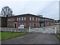
Kier Wisbech - Closed office block
W & C French, see http://en.wikipedia.org/wiki/W._%26_C._French , was a civil engineering company who came to Wisbech in 1929 to rebuild the Nene Quay and at the same time they set up a depot in the town. In 1973 they merged with Kier and became known as French Kier and eventually, after several ownership changes, became known as Kier, see http://en.wikipedia.org/wiki/Kier_Group
This large office block was closed and boarded up in 2013 and the depot and yard now stand empty.
Image: © Richard Humphrey
Taken: 28 Feb 2014
0.08 miles
2

Cromwell Road (B198)
Heading north into Wisbech
Image: © JThomas
Taken: 17 May 2014
0.10 miles
3

Sessions House, South Brink, Wisbech
This historic building is now part of a school. In November 2009 South Brink was closed for repair work.
Image: © Paul Shreeve
Taken: 15 Nov 2009
0.11 miles

5

Wisbech - River Nene from North Brink
Image: © Peter Whatley
Taken: 21 Apr 2010
0.12 miles
6

Welcome To Wisbech
One of the flower arrangements that help to brighten the Town of Wisbech every year.
Thanks to loads of volunteers.
Image: © Tony Bennett
Taken: 15 Aug 2010
0.12 miles
7

B198 South Brink, Wisbech
The far buildings are along North Brink, which is on the other side of the River Nene.
Image: © Robin Webster
Taken: 12 Feb 2018
0.12 miles
8

Welcome to Port of Wisbech
The sign warns traffic coming down the River Nene of the dangers of Wisbech.
Image: © Ben Harris
Taken: 5 Nov 2011
0.13 miles
9
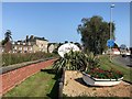
Entering Wisbech on South Brink
The buildings are on the opposite side of the River Nene on North Brink
Image: © Richard Humphrey
Taken: 21 Sep 2020
0.13 miles
10

Edes' Terrace on South Brink, Wisbech
These late Georgian houses were built about the year 1820 by Mr John Edes, who was then Bailiff of Wisbech. The River Nene is in the foreground.
For more information see https://www.wisbech-society.co.uk/town-tour
Image: © Richard Humphrey
Taken: 5 May 2018
0.13 miles