
IMAGES TAKEN NEAR TO
Somers Road, WISBECH, PE13 2RA
Introduction
This page details the photographs taken nearby to Somers Road, PE13 2RA by members of the Geograph project.
The Geograph project started in 2005 with the aim of publishing, organising and preserving representative images for every square kilometre of Great Britain, Ireland and the Isle of Man.

There are currently over 7.5m images from over14,400 individuals and you can help contribute to the project by visiting https://www.geograph.org.uk
Image Map
Images are licensed for reuse under creativecommons.org/licenses/by-sa/2.0
Notes
- Clicking on the map will re-center to the selected point.
- The higher the marker number, the further away the image location is from the centre of the postcode.
Image Listing (546 Images Found)
Images are licensed for reuse under creativecommons.org/licenses/by-sa/2.0
Image
Details
Distance
1

Georgian Terrace, South Brink, Wisbech
Image: © Paul Shreeve
Taken: 15 Nov 2009
0.04 miles
2

Meeting Hall, South Brink, Wisbech
This hall was formerly the library of the boys' grammar school for many years. http://www.wgs.cambs.sch.uk/school_history.html
Image: © Paul Shreeve
Taken: 15 Nov 2009
0.04 miles
3

Wisbech - old school library
For an alternative view, please see Image
Image: © Dave Bevis
Taken: 17 Oct 2011
0.04 miles
4
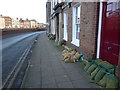
Sandbags by the front doors on South Brink, Wisbech
The entire east coast was battered by a 1-in-60 year tidal surge on the night of Thursday 5th December 2013. A combination of a spring tide, 60 mph winds and a North Sea tidal surge caused the highest tides in over 60 years. Although Wisbech is 10 miles from the coast and 20 miles from the North Sea it is still a flood risk area as it sits on the banks of the tidal River Nene. After parts of the town were flooded in 1978 the height of the river banks was raised by about 1.5 metres, railings were replaced by flood walls and a series of flood gates were built. In the last few years the height of these defences has been raised again by another half metre and work is still ongoing today, replacing metal sheeting defences with concrete and brick walls along Nene Quay. Without these additional flood walls, Wisbech would have suffered severe flooding on Thursday, with the water level above the pre-1978 defences and half way up the additional flood walls. This photo was taken just before the next high tide was due on the following morning which was a couple of metres lower than the surge tide the night before.
Image: © Richard Humphrey
Taken: 6 Dec 2013
0.04 miles
5

Bow-fronted house in a terrace on South Brink, Wisbech
Image: © Chris
Taken: 3 Aug 2015
0.04 miles
6

Wisbech: South Brink Hall
This was the library of the boys' Grammar School from 1898 until 1970, when it amalgamated with the girls' High School and moved across the river to their site on North Brink.
Image: © Michael Garlick
Taken: 17 Jan 2022
0.04 miles
7

Edes' Terrace on South Brink, Wisbech
These late Georgian houses were built about the year 1820 by Mr John Edes, who was then Bailiff of Wisbech. The River Nene is in the foreground.
For more information see https://www.wisbech-society.co.uk/town-tour
Image: © Richard Humphrey
Taken: 5 May 2018
0.05 miles
8
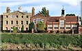
The former Wisbech Grammar School on South Brink
The school library was in the red brick building on the right of photo and the headmaster's study was in the yellow building. It is now a solicitors office and a private residence.
Image: © Richard Humphrey
Taken: 26 May 2019
0.05 miles
9

15 South Brink, Wisbech
Built c1780, extended in 1897-98 for the Grammar School, presumably including the slightly eccentric lantern. Grade II* listed.
Now offices of Bowsers Solicitors.
Image: © Stephen Richards
Taken: 23 May 2016
0.05 miles
