
IMAGES TAKEN NEAR TO
Albion Granary, Nene Quay, WISBECH, PE13 1HY
Introduction
This page details the photographs taken nearby to Albion Granary, Nene Quay, PE13 1HY by members of the Geograph project.
The Geograph project started in 2005 with the aim of publishing, organising and preserving representative images for every square kilometre of Great Britain, Ireland and the Isle of Man.

There are currently over 7.5m images from over14,400 individuals and you can help contribute to the project by visiting https://www.geograph.org.uk
Image Map
Images are licensed for reuse under creativecommons.org/licenses/by-sa/2.0
Notes
- Clicking on the map will re-center to the selected point.
- The higher the marker number, the further away the image location is from the centre of the postcode.
Image Listing (837 Images Found)
Images are licensed for reuse under creativecommons.org/licenses/by-sa/2.0
Image
Details
Distance
1
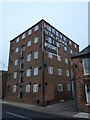
Former riverside warehouse on Nene Quay, Wisbech
The Horace Friend warehouse, designated 'Metal, Feather and Skin Merchant", once gave employment to many people in Wisbech. It is now a block of riverside apartments overlooking the River Nene.
Image: © Richard Humphrey
Taken: 23 Nov 2015
0.01 miles
2

The Horace Friend warehouse on Nene Quay in Wisbech
The Horace Friend warehouse, designated 'Metal, Feather and Skin Merchant", once gave employment to many people in Wisbech. It is now a block of riverside apartments overlooking the River Nene.
See the following for more details https://www.wisbech-society.co.uk/town-tour and see https://www.francisfrith.com/wisbech/wisbech-the-bridge-c1955_w115037 for a view of the quay in 1955
Image: © Richard Humphrey
Taken: 8 Dec 2017
0.01 miles
3

Wisbech in Bloom 2019 - A view along Nene Quay
Image: © Richard Humphrey
Taken: 26 Aug 2019
0.01 miles
4

River Nene
Looking north east along the River Nene Wisbech Cambridgeshire.
Image: © Keith Evans
Taken: 27 May 2008
0.01 miles
5
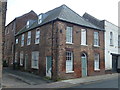
The Anchor - Public Houses, Inns and Taverns of Wisbech
This building was once The Anchor Inn at 9 Nene Quay, Wisbech. It is now a domestic dwelling. It is named on the 1887 OS map of Wisbech, see https://www.old-maps.co.uk/#/Map/546227/310115/13/100091
Image: © Richard Humphrey
Taken: 8 Jan 2016
0.01 miles
6
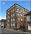
Former riverside warehouse on Nene Quay in Wisbech
This warehouse was owned by Horace Friend who was a metal, feather and skin merchant. It is now riverside apartments.
Image: © Richard Humphrey
Taken: 16 Mar 2020
0.01 miles
7

Old barn in New Inn Yard, Wisbech
For more details of this historic building just off The Market Place, see the Wisbech Society website here http://www.wisbech-society.co.uk/oldbarn.html
Image: © Richard Humphrey
Taken: 19 Jan 2016
0.01 miles
8

Building on the Nene Quay, corner of Hill Street
Seems to have enjoyed a brief career as a Chinese take-away.
Image: © Chris
Taken: 3 Aug 2015
0.01 miles
9

Former inn and warehouse on Nene Quay, Wisbech
Both these riverside buildings are now used as domestic dwellings.
Image: © Richard Humphrey
Taken: 11 Dec 2015
0.02 miles
10

The River Nene at Wisbech
The River Nene was diverted to serve the town in C17 after the estuary of the Great Ouse became silted up and unusable for navigation.
Image: © Bikeboy
Taken: 14 Apr 2015
0.02 miles