
IMAGES TAKEN NEAR TO
St. Laurence Close, SPALDING, PE11 4EH
Introduction
This page details the photographs taken nearby to St. Laurence Close, PE11 4EH by members of the Geograph project.
The Geograph project started in 2005 with the aim of publishing, organising and preserving representative images for every square kilometre of Great Britain, Ireland and the Isle of Man.

There are currently over 7.5m images from over14,400 individuals and you can help contribute to the project by visiting https://www.geograph.org.uk
Image Map
Images are licensed for reuse under creativecommons.org/licenses/by-sa/2.0
Notes
- Clicking on the map will re-center to the selected point.
- The higher the marker number, the further away the image location is from the centre of the postcode.
Image Listing (44 Images Found)
Images are licensed for reuse under creativecommons.org/licenses/by-sa/2.0
Image
Details
Distance

2

Old Milestone, B1356, Goldsmith Road
The milestone is located on the verge in front of Church Drive on the west side of the road. Parish of Surfleet (South Holland district). Carved stone post, erected by Spalding & Donington turnpike trust in the 19th century. Raised in 2020, having been almost completely buried, and recently repainted. See also https://www.geograph.org.uk/photo/6530341
Inscription reads:
BOSTON / 12 / MILES / SURFLEET // SPALDING / 4 / MILES / SURFLEET
Milestone Society National ID: LI_SPBO04
Image: © Philip Godderidge
Taken: 21 Jul 2022
0.02 miles
3

B1356, Surfleet
On the left the Mermaid Inn. To the rear, the leaning tower of the Church of St Lawrence. The tower is 6 feet out of perpendicular. The road, from Spalding, links up with the A152 on its way northwards to the A52.
Image: © Dave Hitchborne
Taken: 1 Jun 2004
0.09 miles


6

Yes, it is leaning
View down the main road through Surfleet. St Laurence Church appears to be bending over to watch you as you pass by. That's because it is! http://www.glengroup.org.uk/St%20Laurence's%20Surfleet.htm
Image: © Ian Paterson
Taken: 29 Apr 2012
0.10 miles

8

Church of St Laurence: The Font
An early 15th century font, here decorated for the harvest festival.
The church is grade I listed - see https://historicengland.org.uk/listing/the-list/list-entry/1064403?section=official-list-entry .
Image: © Bob Harvey
Taken: 30 Sep 2023
0.10 miles
9
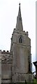
The leaning tower
The tower of St Laurence's church is renowned for its leaning tower, and the spire which has its own lean. The churchwarden tells me that the two largest bells (they have a ring of 12) is outside the footprint of the church at ground level.
The sightlines are not brilliant when it comes to portrating this fascinating feature.
This is a grade I listed building - seee https://historicengland.org.uk/listing/the-list/list-entry/1064403?section=official-list-entry .
Image: © Bob Harvey
Taken: 30 Sep 2023
0.10 miles
10

Surfleet - the pub, the church, the bridge, the river
Four of the features of the village of Surfleet. The Mermaid Inn, St. Laurence's Church (leaning at an alarming angle), the iron girder bridge and the River Glen around which Surfleet was built.
Image: © Graham Horn
Taken: 21 Apr 2007
0.10 miles