
IMAGES TAKEN NEAR TO
Wisteria Way, BOURNE, PE10 9SY
Introduction
This page details the photographs taken nearby to Wisteria Way, PE10 9SY by members of the Geograph project.
The Geograph project started in 2005 with the aim of publishing, organising and preserving representative images for every square kilometre of Great Britain, Ireland and the Isle of Man.

There are currently over 7.5m images from over14,400 individuals and you can help contribute to the project by visiting https://www.geograph.org.uk
Image Map
Images are licensed for reuse under creativecommons.org/licenses/by-sa/2.0
Notes
- Clicking on the map will re-center to the selected point.
- The higher the marker number, the further away the image location is from the centre of the postcode.
Image Listing (147 Images Found)
Images are licensed for reuse under creativecommons.org/licenses/by-sa/2.0
Image
Details
Distance
1

House in Wisteria Way
This house cheered me up. They have put on a show for the neighbours during these difficult time. As well as Santa we have a whole bay window with an NHS rainbow of hope and posters of support. Here is a family facing the pandemic and shouting defiance.
Image: © Bob Harvey
Taken: 26 Dec 2020
0.01 miles


4

The turn-around.
So many of these little estate roads are dead-ends, and all have a turning place at the end. This is Wisteria Way. Note the longitudinal hedge dividing two driveways.
Image: © Bob Harvey
Taken: 26 Dec 2020
0.03 miles
5

Suburban junction
The junction of Wisteria way and Hawthorn Road.
Image: © Bob Harvey
Taken: 26 Dec 2020
0.05 miles
6

The top end
Holly Drive is three sides of a square, ending as a cul-de-sac. The northernmost bit, is known as "the top end".
Image: © Bob Harvey
Taken: 14 Dec 2020
0.06 miles

8

A bit safer
The precarious state of the wreckage seen in Image has been reduced to a gravitationally stable form. It may, I suspect, be like this for a while.
Image: © Bob Harvey
Taken: 26 Dec 2020
0.08 miles
9

Lavender Way
Another little close of houses and bungalows built as the 21st century got going.
Image: © Bob Harvey
Taken: 1 Dec 2013
0.08 miles
10
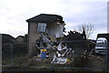
The remains of a house
On Sunday 13th of December the occupant of this house had a lucky escape. The act of switching on a kettle caused a gas explosion which wrecked the house but left him with only minor injuries.
The emergency services arrived within minutes, police, fire, ambulance, and the whole incident was handled with huge professionalism in the midst of a pandemic. The story was covered by the news media within the hour: https://www.stamfordmercury.co.uk/news/gas-explosion-causes-house-to-collapse-9145018/ , https://www.spaldingtoday.co.uk/news/gas-explosion-causes-house-to-collapse-9145019/ , https://www.bbc.co.uk/news/uk-england-lincolnshire-55279445
The owner of the camper van, a relative of the neighbour, told me he cannot move his vehicle until the formal investigation is over.
Image: © Bob Harvey
Taken: 14 Dec 2020
0.08 miles