
IMAGES TAKEN NEAR TO
West Road, BOURNE, PE10 0LB
Introduction
This page details the photographs taken nearby to West Road, PE10 0LB by members of the Geograph project.
The Geograph project started in 2005 with the aim of publishing, organising and preserving representative images for every square kilometre of Great Britain, Ireland and the Isle of Man.

There are currently over 7.5m images from over14,400 individuals and you can help contribute to the project by visiting https://www.geograph.org.uk
Image Map
Images are licensed for reuse under creativecommons.org/licenses/by-sa/2.0
Notes
- Clicking on the map will re-center to the selected point.
- The higher the marker number, the further away the image location is from the centre of the postcode.
Image Listing (148 Images Found)
Images are licensed for reuse under creativecommons.org/licenses/by-sa/2.0
Image
Details
Distance
1
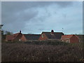
Out-of-town housing
Three tiny bungalows have been in this field since the early 1900s. In recent years the middle one has been torn down and rebuilt slightly larger, then the nearer one was cleverly extended. The furthest one was demolished and a much larger two storey house is in the process of being built.
Image: © Bob Harvey
Taken: 23 Dec 2012
0.01 miles

3

The A151 west out of Bourne
The road gradually climbs up from the flat land of The Fens. The path to the right leads to Bourne Woods
Image: © Tim Heaton
Taken: 15 Feb 2018
0.03 miles
4

Pillbox
World war two gun emplacement overgrown by trees and moss.
Although originally in a corner of a field when built, the location is now fenced off from the field. The land on which the pillbox was built was not returned to the farmer after the war but retained, along with the adjacent track, by the Forestry Commission.
Image: © Bob Harvey
Taken: 23 Dec 2012
0.04 miles
5

Looking toward the end
Looking roughly south towards West road
Image: © Bob Harvey
Taken: 24 May 2020
0.05 miles
6

Inhabitant
One of the Sheep at Park Farm
Image: © Bob Harvey
Taken: 23 Dec 2012
0.05 miles
7

The path to the woods
Normally only a preserve of dog-walkers and very occasional birdwatchers, this is now busy with people who have become accustomed to taking exercise in Bourne Woods during the Covid-19 shutdown. Oh look, there is one now! Me too, I was walking back this way having walked down to the Elsea Park Co-op for emergency milk and much-needed bread.
The path is lined with all sorts of wild plants, the cow parsley is very heavy right now. On the left some late Hawthorn blossom. See Image and Image for closer views.
Bending down on the right to look under the hedge canopy I spotted some cattle lying down: Image
Image: © Bob Harvey
Taken: 24 May 2020
0.05 miles
8
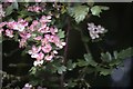
Pink Hawthorn Blossom
As seen on the left in Image
Image: © Bob Harvey
Taken: 24 May 2020
0.05 miles
9

Pink Hawthorn Blossom
As seen on the left in Image
Image: © Bob Harvey
Taken: 24 May 2020
0.05 miles
10
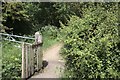
No more kissing
This is the entrance to a path that leads into Bourne Woods from West Road.
The small wooden gate replaces a former kissing gate that prevented cattle escaping onto the road when moved from fields on one side of the path to the other.
According to the sign at the other end (Image) this is a Restricted Byway, rather than a public footpath. There is no sign at this end.
Invisible in the hedgerow on the left is a World War 2 pillbox.
Image: © Bob Harvey
Taken: 24 May 2020
0.05 miles