
IMAGES TAKEN NEAR TO
Northorpe Lane, BOURNE, PE10 0HE
Introduction
This page details the photographs taken nearby to Northorpe Lane, PE10 0HE by members of the Geograph project.
The Geograph project started in 2005 with the aim of publishing, organising and preserving representative images for every square kilometre of Great Britain, Ireland and the Isle of Man.

There are currently over 7.5m images from over14,400 individuals and you can help contribute to the project by visiting https://www.geograph.org.uk
Image Map
Images are licensed for reuse under creativecommons.org/licenses/by-sa/2.0
Notes
- Clicking on the map will re-center to the selected point.
- The higher the marker number, the further away the image location is from the centre of the postcode.
Image Listing (33 Images Found)
Images are licensed for reuse under creativecommons.org/licenses/by-sa/2.0
Image
Details
Distance
1

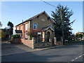
The old Methodist chapel at Thurlby, near Bourne, Lincolnshire
The chapel with its distinctive yellow brick façade, red brick side walls and blue slate roof was built in 1861 and became known as the Top Chapel because of its location at the top end of the village but closed in 1971 and now converted for use as a private house although much of the original exterior has been left intact.
Image: © Rex Needle
Taken: 9 Jun 2000
0.04 miles

3
Free Methodist Chapel (former), Thurlby
Built in 1861, used by the United Methodists, and known as 'Top Chapel'. Closed in 1974, with the congregation moving to the church on the High Street Image
Image: © Tim Heaton
Taken: 8 Nov 2009
0.06 miles

5
Datestone
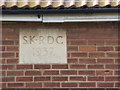
Datestone on the houses in Image] . The lettering refers to the former South Kesteven Rural District Council.
There are 3 blocks each of 4 cottages, but only the left and centre ones have these datestones.
Image: © Bob Harvey
Taken: 18 Oct 2014
0.07 miles
6
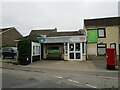
Village store and Post Office, Thurlby
Image: © Jonathan Thacker
Taken: 1 Sep 2021
0.08 miles
7

Farmworkers Cottages
Three blocks of cottages built in 1937 to house farm workers in the village. Built by the then South Kesteven Rural District Council
Image: © Bob Harvey
Taken: 18 Oct 2014
0.08 miles

9

Arms of South Kesteven Rural District Council
A plaque with the arms of South Kesteven Rural District Council graces the central house in Maple Avenue (Image]).
This plaque appears to be identical to the one in Image] on the back of an office built in Bourne for the same body.
Image: © Bob Harvey
Taken: 18 Oct 2014
0.08 miles
10
Maple Avenue
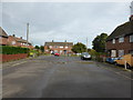
This little close of semidetached council houses was built in the immediate post-war years by the then South Kesteven Rural District Council.
The houses and gardens are far larger than modern homes, and might certainly be regarded as 'homes fit for heroes'.
Image: © Bob Harvey
Taken: 18 Oct 2014
0.08 miles