IMAGES TAKEN NEAR TO
Falcon Way, BOURNE, PE10 0GT
Introduction
This page details the photographs taken nearby to Falcon Way, PE10 0GT by members of the Geograph project.
The Geograph project started in 2005 with the aim of publishing, organising and preserving representative images for every square kilometre of Great Britain, Ireland and the Isle of Man.

There are currently over 7.5m images from over14,400 individuals and you can help contribute to the project by visiting https://www.geograph.org.uk
Image Map
Images are licensed for reuse under creativecommons.org/licenses/by-sa/2.0
Notes
- Clicking on the map will re-center to the selected point.
- The higher the marker number, the further away the image location is from the centre of the postcode.
Image Listing (97 Images Found)
Images are licensed for reuse under creativecommons.org/licenses/by-sa/2.0
Image
Details
Distance
1
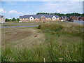
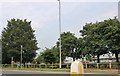
New development in Bourne
This development off South Road is so new that at the moment it does not appear on the Ordnance Survey or on Google Maps. The building in the centre is a care home whilst new housing is to the left and right. Doubtless other buildings will follow.
Image: © Marathon
Taken: 2 Jul 2011
0.01 miles
2
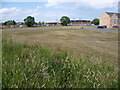
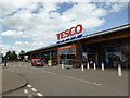
Supermarket off South Road, Bourne
Apart from the supermarket, the rest of the development in this area off South Road is so new that at the moment it does not appear on the Ordnance Survey or on Google Maps. Doubtless other buildings will follow.
Image: © Marathon
Taken: 2 Jul 2011
0.04 miles
3
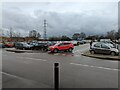
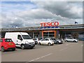
Tesco carpark
I have no idea why the council think they can allow the town to double in size again. There are already twice as many homes as when they gave permission for this, and some of those were built on what had been the similarly sized Co-op "Rainbow" superstore. It really worries me where all these proposed folk are supposed to shop, work, or go to school.
Image: © Bob Harvey
Taken: 14 Jan 2023
0.07 miles
5
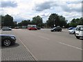
Tesco in Bourne
Opened with great fanfare a decade ago as being "carbon neutral", summat we have not heard much of lately. Recently closed the deli counters so it is a large convenience store now, selling only prepacks. The bread is still final-baked on the premises, being delivered chilled and provedfrom elsewhere.
Image: © Bob Harvey
Taken: 30 Jun 2019
0.08 miles
8
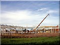
Tesco takes shape at Bourne, Lincolnshire
Work began on Tesco’s new store in South Road in September 2010 and opened five months later on Monday 21st February 2011 with a cake and champagne launch when 3,500 customers passed through the checkouts and it remains the biggest single retail outlet in the town.
Image: © Rex Needle
Taken: 30 Oct 2010
0.09 miles
10
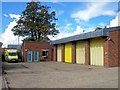
Ambulance station at Bourne, Lincolnshire
The present ambulance station was opened on a site at the corner of the Bourne Hospital complex in South Road in 1980 following a disastrous fire which wrecked the previous headquarters in Queen’s Road. The hospital has now closed and the buildings demolished and replaced by a housing estate but the ambulance station remains although financial restraints within the East Midlands Ambulance Service make its future uncertain.
Image: © Rex Needle
Taken: 19 Sep 2011
0.09 miles