
IMAGES TAKEN NEAR TO
Coppice Way, BOURNE, PE10 0GF
Introduction
This page details the photographs taken nearby to Coppice Way, PE10 0GF by members of the Geograph project.
The Geograph project started in 2005 with the aim of publishing, organising and preserving representative images for every square kilometre of Great Britain, Ireland and the Isle of Man.

There are currently over 7.5m images from over14,400 individuals and you can help contribute to the project by visiting https://www.geograph.org.uk
Image Map
Images are licensed for reuse under creativecommons.org/licenses/by-sa/2.0
Notes
- Clicking on the map will re-center to the selected point.
- The higher the marker number, the further away the image location is from the centre of the postcode.
Image Listing (92 Images Found)
Images are licensed for reuse under creativecommons.org/licenses/by-sa/2.0
Image
Details
Distance
1

Elsea Park
Part of the once-controversial Elsea Park estate, built by Larkfleet homes.
Image: © Bob Harvey
Taken: 16 Aug 2014
0.12 miles
2

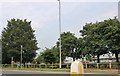
South Road in Bourne
At the junction with Eagle Road.
Image: © Mat Fascione
Taken: 12 Apr 2014
0.12 miles
4

House and Office
More and more people in Bourne work from home, but few put business signage on their homes.
Image: © Bob Harvey
Taken: 16 Aug 2014
0.14 miles
5

The Ostler memorial at Bourne, Lincolnshire
The memorial drinking fountain erected to celebrate the life of John Lely Ostler (1811-59) began life in the market place, now the town centre, but was moved to the cemetery in 1962 and is pictured here before being Grade II listed and restored by the town council at a cost of £9,000 - see Image
Image: © Rex Needle
Taken: 10 Jun 2000
0.14 miles
6
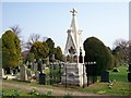
The Ostler memorial, Bourne, Lincolnshire
One of the few stone monuments in Bourne is the Ostler memorial fountain, a fine example of Victorian gothic erected by public subscription in 1860 as a memorial to one of the town's 19th century worthies, property owner John Lely Ostler (1811-59), and paid for by public subscription. The fountain was originally sited in the market place but a century later it had become an obstruction to increasing traffic flows and so in 1962 it was moved stone by stone to the town’s cemetery in South Road. In July 2007, the fountain was given a Grade II listing and Bourne Town Council subsequently agreed to spend £9,000 on restoration which included the erection of protective iron railings. See the memorial before restoration Image
Image: © Rex Needle
Taken: 18 Mar 2009
0.14 miles
7
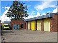
Ambulance station at Bourne, Lincolnshire
The present ambulance station was opened on a site at the corner of the Bourne Hospital complex in South Road in 1980 following a disastrous fire which wrecked the previous headquarters in Queen’s Road. The hospital has now closed and the buildings demolished and replaced by a housing estate but the ambulance station remains although financial restraints within the East Midlands Ambulance Service make its future uncertain.
Image: © Rex Needle
Taken: 19 Sep 2011
0.15 miles
8
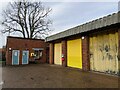
Bourne Ambulance Station
There used to be an ambulance garage at the fire station, but it was destroyed in a terrible fatal fire.
The replacement was built here, which at the time was in the grounds of the isolation hospital. That facility was torn away from us by NHS management, and in recent years the merger of the Lincolnshire and Nottinghamshire ambulance trusts nearly cost us the ambulance station too. But we need it, and much agitation saved the facility.
The ambulance station is now tucked away in a housing estate built where the hospital once stood.
Image: © Bob Harvey
Taken: 22 Dec 2020
0.15 miles

10

Public conveniences, Bourne Cemetery
Like the cemetery; clean and tidy.
Image: © Tim Heaton
Taken: 8 Nov 2009
0.15 miles