
IMAGES TAKEN NEAR TO
Windle Drive, BOURNE, PE10 0DB
Introduction
This page details the photographs taken nearby to Windle Drive, PE10 0DB by members of the Geograph project.
The Geograph project started in 2005 with the aim of publishing, organising and preserving representative images for every square kilometre of Great Britain, Ireland and the Isle of Man.

There are currently over 7.5m images from over14,400 individuals and you can help contribute to the project by visiting https://www.geograph.org.uk
Image Map
Images are licensed for reuse under creativecommons.org/licenses/by-sa/2.0
Notes
- Clicking on the map will re-center to the selected point.
- The higher the marker number, the further away the image location is from the centre of the postcode.
Image Listing (56 Images Found)
Images are licensed for reuse under creativecommons.org/licenses/by-sa/2.0
Image
Details
Distance
1

Car Dyke on the edge of Bourne
An insignificant drain that was once believed to be a Roman Canal. That assertion is now debated https://en.wikipedia.org/wiki/Car_Dyke
Image: © Jonathan Thacker
Taken: 11 Oct 2021
0.05 miles
2

Car Dyke, looking towards the southern edge of Bourne
Image: © Tim Heaton
Taken: 7 Mar 2018
0.06 miles
3

Demolition of Bourne Hospital, Lincolnshire
Bourne Hospital closed in 1998 after a valiant public campaign to keep it open including a petition signed by 8,000 people and was demolished in the summer of 2003 to make way for new homes which have since been built on the four acre site. The hospital opened in 1915 as an isolation unit for patients with infectious diseases and expanded to become a cottage hospital providing a much needed medical amenity for the town and district but now it has gone, patients are sent to Peterborough, 17 miles away.
Image: © Rex Needle
Taken: 11 Jun 2003
0.06 miles


6
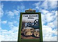
Sugar Mill pub sign at Bourne, Lincolnshire
The latest public house and restaurant to open at Bourne is the Sugar Mill in South Road which began business in December 2012, so named and illustrated by their pub sign because of the area’s connection with growing beet for the sugar processing industry.
Image: © Rex Needle
Taken: 3 Dec 2012
0.07 miles
8
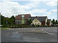
The Sugar Mill
The name is something of a mockery. Built in the field in which the UK's first ever crop of sugar beet was raised, the name is supposed in some wise to commemorate that. But there was never a Sugar Mill here, and I don't think that the name "Sugar Mill" was ever widely used.
This is a restaurant rather than a pub.
Image: © Bob Harvey
Taken: 31 May 2017
0.07 miles
9

Bourne Hospital, Lincolnshire
Bourne Hospital opened in 1915 as an isolation unit for patients suffering from infectious diseases and over the years expanded to become a cottage hospital providing a much needed medical amenity for the town and district. By 1965, it was being run as a medical and surgical unit with 53 beds and fully staffed by medical personnel with a chest X-ray unit and clinics specialising in the eyes, orthopaedics, remedial and relaxation therapy and child welfare. The hospital closed in 1998 and was demolished five years later to make way for new housing. See Image
Image: © Rex Needle
Taken: 18 May 2001
0.08 miles
