IMAGES TAKEN NEAR TO
Bowfield Road, JOHNSTONE, PA9 1DA
Introduction
This page details the photographs taken nearby to Bowfield Road, PA9 1DA by members of the Geograph project.
The Geograph project started in 2005 with the aim of publishing, organising and preserving representative images for every square kilometre of Great Britain, Ireland and the Isle of Man.

There are currently over 7.5m images from over14,400 individuals and you can help contribute to the project by visiting https://www.geograph.org.uk
Image Map (2 Images)


Getting Data...Please wait
Leaflet Map data © OpenStreetMap
Images are licensed for reuse under creativecommons.org/licenses/by-sa/2.0
Notes
- Clicking on the map will re-center to the selected point.
- The higher the marker number, the further away the image location is from the centre of the postcode.
Image Listing (2 Images Found)
Images are licensed for reuse under creativecommons.org/licenses/by-sa/2.0
Image
Details
Distance
1
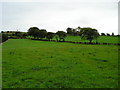
More Grass
Fields of grass at South Muirdykes farm
Image: © Chris Court
Taken: 18 Sep 2005
0.16 miles
2
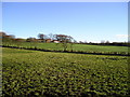
Winter Sunshine
South Muirdykes farm with the winter sunshine creating shadows in every hoofprint made in the field in the foreground.This picture was taken at around 1345 hrs.
Image: © Chris Court
Taken: 29 Nov 2005
0.21 miles