IMAGES TAKEN NEAR TO
Hill Road, JOHNSTONE, PA9 1BU
Introduction
This page details the photographs taken nearby to Hill Road, PA9 1BU by members of the Geograph project.
The Geograph project started in 2005 with the aim of publishing, organising and preserving representative images for every square kilometre of Great Britain, Ireland and the Isle of Man.

There are currently over 7.5m images from over14,400 individuals and you can help contribute to the project by visiting https://www.geograph.org.uk
Image Map (Loading...)


Getting Data...Please wait
Leaflet Map data © OpenStreetMap
Images are licensed for reuse under creativecommons.org/licenses/by-sa/2.0
Notes
- Clicking on the map will re-center to the selected point.
- The higher the marker number, the further away the image location is from the centre of the postcode.
Image Listing (18 Images Found)
Images are licensed for reuse under creativecommons.org/licenses/by-sa/2.0
Image
Details
Distance
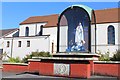
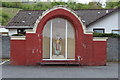
1
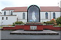
Church of Christ the King, Howwood
Statue of Our Lady Of Fatima.
Image: © Billy McCrorie
Taken: 18 May 2016
0.08 miles
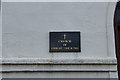
2
Church of Christ The King, Bowfield Road, Howwood
Image: © Leslie Barrie
Taken: 10 Jul 2014
0.08 miles
3
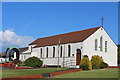
Church of Christ The King, Bowfield Road, Howwood
Image: © Leslie Barrie
Taken: 10 Jul 2014
0.08 miles
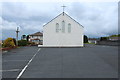
6
Church of Christ the King, Howwood
Statue of Christ.
Image: © Billy McCrorie
Taken: 18 May 2016
0.09 miles
7
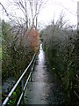
Damp alley
This rather steeply descending footpath through a residential portion of Howwood runs parallel to a small burn.
Image: © Mark Nightingale
Taken: 9 Mar 2009
0.10 miles