IMAGES TAKEN NEAR TO
Midton Road, JOHNSTONE, PA9 1AL
Introduction
This page details the photographs taken nearby to Midton Road, PA9 1AL by members of the Geograph project.
The Geograph project started in 2005 with the aim of publishing, organising and preserving representative images for every square kilometre of Great Britain, Ireland and the Isle of Man.

There are currently over 7.5m images from over14,400 individuals and you can help contribute to the project by visiting https://www.geograph.org.uk
Image Map
Images are licensed for reuse under creativecommons.org/licenses/by-sa/2.0
Notes
- Clicking on the map will re-center to the selected point.
- The higher the marker number, the further away the image location is from the centre of the postcode.
Image Listing (10 Images Found)
Images are licensed for reuse under creativecommons.org/licenses/by-sa/2.0
Image
Details
Distance
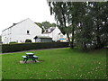
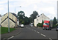
1
Howwood Sports Pavilion
In the public park.
Image: © Gordon Dowie
Taken: 11 May 2010
0.03 miles
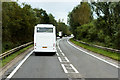
2
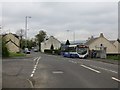
Main Street, Howwood
McGill's bus on the way to Paisley.
Image: © Richard Webb
Taken: 25 Apr 2014
0.19 miles
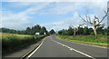
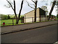
7
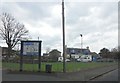
Howwood, Renfrewshire
Village of 1500 inhabitants southwest of Paisley and Johnstone.
Image: © Stephen Sweeney
Taken: 6 Apr 2015
0.24 miles