IMAGES TAKEN NEAR TO
Mains River, ERSKINE, PA8 7JP
Introduction
This page details the photographs taken nearby to Mains River, PA8 7JP by members of the Geograph project.
The Geograph project started in 2005 with the aim of publishing, organising and preserving representative images for every square kilometre of Great Britain, Ireland and the Isle of Man.

There are currently over 7.5m images from over14,400 individuals and you can help contribute to the project by visiting https://www.geograph.org.uk
Image Map
Images are licensed for reuse under creativecommons.org/licenses/by-sa/2.0
Notes
- Clicking on the map will re-center to the selected point.
- The higher the marker number, the further away the image location is from the centre of the postcode.
Image Listing (19 Images Found)
Images are licensed for reuse under creativecommons.org/licenses/by-sa/2.0
Image
Details
Distance
1

Footpath beside Newshot Island LNR
The footpath goes past the edge of Newshot Island Local Nature Reserve and leads to Newshot Drive.
Image: © Richard Sutcliffe
Taken: 16 Jan 2022
0.04 miles
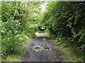
2

Footpath, Newshot Island Local Nature Reserve
Image: © Richard Sutcliffe
Taken: 16 Jan 2022
0.07 miles
3
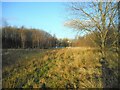
Clearing, Newshot Island LNR
A clearing within the wooded area of Newshot Island Local Nature Reserve.
Image: © Richard Sutcliffe
Taken: 16 Jan 2022
0.10 miles

5
Path in Newshot Island Local Nature Reserve
The nature reserve is a recent project in the regeneration of the Clyde Waterfront - in stark contrast to the regeneration works on the north bank, which mainly consist of building new housing and offices.
Image: © Stephen Sweeney
Taken: 21 Jul 2007
0.13 miles
6
Newshot Island Local Nature Reserve, Erskine
Image: © Leslie Barrie
Taken: 24 Mar 2014
0.15 miles
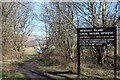
7
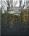
Sign for Newshot Island Local Nature Reserve
Erskine's only Nature Reserve. The Inner Clyde estuary is an internationally designated site for the protection of wintering wading birds.
Image: © Richard Sutcliffe
Taken: 16 Jan 2022
0.16 miles
8
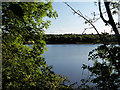
River Clyde, Erskine
Looking across the river from Clydebank Industrial estate, through a gap in the hedge, towards Erskine on the opposite bank.
Image: © David Dixon
Taken: 2 Aug 2019
0.17 miles
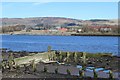
9

Newshot Island Boat Graveyard
Two of about 50 barges, punts and other vessels abandoned in the mud between Erskine and Newshot Island. Many of these were used during the deepening of the channel of the River Clyde in the late 19th and early 20th centuries.
Image: © Richard Sutcliffe
Taken: 16 Jan 2022
0.17 miles