IMAGES TAKEN NEAR TO
Park Moor, ERSKINE, PA8 7HL
Introduction
This page details the photographs taken nearby to Park Moor, PA8 7HL by members of the Geograph project.
The Geograph project started in 2005 with the aim of publishing, organising and preserving representative images for every square kilometre of Great Britain, Ireland and the Isle of Man.

There are currently over 7.5m images from over14,400 individuals and you can help contribute to the project by visiting https://www.geograph.org.uk
Image Map
Images are licensed for reuse under creativecommons.org/licenses/by-sa/2.0
Notes
- Clicking on the map will re-center to the selected point.
- The higher the marker number, the further away the image location is from the centre of the postcode.
Image Listing (6 Images Found)
Images are licensed for reuse under creativecommons.org/licenses/by-sa/2.0
Image
Details
Distance
1
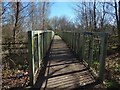
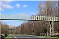
Footbridge over the A726
For more context, see Image, which shows it from the side.
Image: © Lairich Rig
Taken: 27 Mar 2017
0.19 miles
2
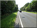
The A726 road through Erskine
Formerly served the Erskine ferry, but was re-routed and upgraded when the Erskine bridge was opened and Erskine New Community was built in the early 1970s.
Image: © Thomas Nugent
Taken: 25 Aug 2018
0.20 miles
5
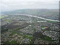
View over Erskine
Product of late 20th C expansion
Image: © Jim Smillie
Taken: 7 Apr 2011
0.21 miles
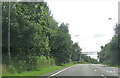
6
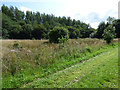
Verge by the A726 road in Erskine
East of the road, approaching southolm Roundabout from the north.
Image: © Thomas Nugent
Taken: 25 Aug 2018
0.25 miles