IMAGES TAKEN NEAR TO
Turnyland Way, ERSKINE, PA8 7ET
Introduction
This page details the photographs taken nearby to Turnyland Way, PA8 7ET by members of the Geograph project.
The Geograph project started in 2005 with the aim of publishing, organising and preserving representative images for every square kilometre of Great Britain, Ireland and the Isle of Man.

There are currently over 7.5m images from over14,400 individuals and you can help contribute to the project by visiting https://www.geograph.org.uk
Image Map
Images are licensed for reuse under creativecommons.org/licenses/by-sa/2.0
Notes
- Clicking on the map will re-center to the selected point.
- The higher the marker number, the further away the image location is from the centre of the postcode.
Image Listing (15 Images Found)
Images are licensed for reuse under creativecommons.org/licenses/by-sa/2.0
Image
Details
Distance
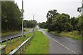
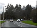
3
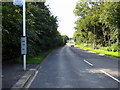
Parkway
A short stretch of dual carriageway where the road crosses a footpath south of Park Gate.
Image: © Thomas Nugent
Taken: 25 Aug 2018
0.08 miles
4
Parkway
Formerly known as Old Greenock Road.
Image: © Thomas Nugent
Taken: 25 Aug 2018
0.11 miles
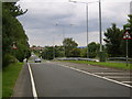
5
Parkway
Looking west from the roundabout at Parksail.
Image: © Thomas Nugent
Taken: 25 Aug 2018
0.21 miles
6
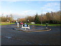
Southholm Roundabout
Roundabout on the A726 just south of Erskine.
Image: © G Laird
Taken: 17 Dec 2013
0.22 miles
7
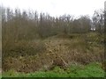
Rashielee Plantation
A view from beside the A726 in Erskine. This would have been near the edge of a woodland before Erskine was built. Much of the Rashielee woodlands have survived on the other side of the distribution road.
Image: © Richard Webb
Taken: 4 Jan 2016
0.23 miles
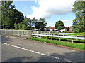
8
Southholm Roundabout
And a sign on the wall letting us know we are in Erskine.
Image: © Stephen Sweeney
Taken: 21 Jul 2007
0.23 miles
9
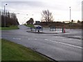
Southholm Roundabout
Turn left for Erskine Bridge
Image: © william craig
Taken: 21 Jan 2006
0.23 miles
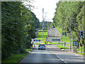
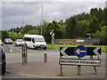
10
Southholm roundabout
Here the modern A726 distribution road meets the original road from the days before Erskine was built. This is now the Parkway, which is another distribution road for Erskine. The junction is within Rashielee Plantation, so little indication that this is an urban area.
Image: © Richard Webb
Taken: 4 Jan 2016
0.24 miles