IMAGES TAKEN NEAR TO
Craigiehall Crescent, ERSKINE, PA8 7DD
Introduction
This page details the photographs taken nearby to Craigiehall Crescent, PA8 7DD by members of the Geograph project.
The Geograph project started in 2005 with the aim of publishing, organising and preserving representative images for every square kilometre of Great Britain, Ireland and the Isle of Man.

There are currently over 7.5m images from over14,400 individuals and you can help contribute to the project by visiting https://www.geograph.org.uk
Image Map
Images are licensed for reuse under creativecommons.org/licenses/by-sa/2.0
Notes
- Clicking on the map will re-center to the selected point.
- The higher the marker number, the further away the image location is from the centre of the postcode.
Image Listing (7 Images Found)
Images are licensed for reuse under creativecommons.org/licenses/by-sa/2.0
Image
Details
Distance
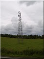
1
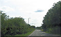
A726 south of Southholme roundabout
Power lines cross in distance
Image: © John Firth
Taken: 25 Jul 2012
0.06 miles
2
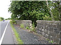
Damaged wall by Southbar Road
Looking South.
Image: © Stephen Sweeney
Taken: 21 Jul 2007
0.13 miles
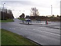
3
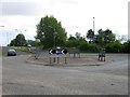
Southholm Roundabout
Roundabout on the A726 just south of Erskine.
Image: © G Laird
Taken: 17 Dec 2013
0.23 miles
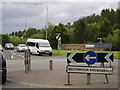
5
Southholm Roundabout
Turn left for Erskine Bridge
Image: © william craig
Taken: 21 Jan 2006
0.24 miles
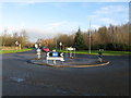
6
Southholm Roundabout
And a sign on the wall letting us know we are in Erskine.
Image: © Stephen Sweeney
Taken: 21 Jul 2007
0.24 miles