IMAGES TAKEN NEAR TO
Hawthorn Crescent, ERSKINE, PA8 7BY
Introduction
This page details the photographs taken nearby to Hawthorn Crescent, PA8 7BY by members of the Geograph project.
The Geograph project started in 2005 with the aim of publishing, organising and preserving representative images for every square kilometre of Great Britain, Ireland and the Isle of Man.

There are currently over 7.5m images from over14,400 individuals and you can help contribute to the project by visiting https://www.geograph.org.uk
Image Map
Images are licensed for reuse under creativecommons.org/licenses/by-sa/2.0
Notes
- Clicking on the map will re-center to the selected point.
- The higher the marker number, the further away the image location is from the centre of the postcode.
Image Listing (11 Images Found)
Images are licensed for reuse under creativecommons.org/licenses/by-sa/2.0
Image
Details
Distance
2
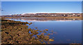
Newshot Island Inlet, River Clyde
Looking downstream to the Erskine Bridge. Clydebank hospital on the right. Kilpatrick Hills in the distance.
Image: © wfmillar
Taken: 1 Mar 2010
0.13 miles
3
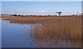
Reeds at Newshot Island, River Clyde
Clydebank's Titan Crane in the distance.
Image: © wfmillar
Taken: 1 Mar 2010
0.15 miles
4
Newshot Island,River Clyde
Looking across the inlet at Newshot Island to Clydebank. Clydebank Hospital on the left.
Image: © wfmillar
Taken: 1 Mar 2010
0.16 miles
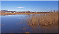
5
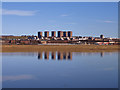
Inlet at Newshot Island, River Clyde
Reflection of the high rise flats at Radnor Park, Clydebank on the inlet waters. Newshot Island is the long brown strip of reeds.
Image: © wfmillar
Taken: 1 Mar 2010
0.16 miles
6
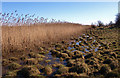
Reeds at Newshot Island, River Clyde
The edge of the reed bed meets farmland.
Image: © wfmillar
Taken: 1 Mar 2010
0.16 miles
7
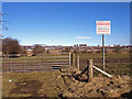
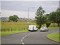
Access to farmland from Flures Avenue, Inchinnan
A small strip of land between Newshot Island and Inchinnan prone to flooding from the River Clyde.
Image: © wfmillar
Taken: 1 Mar 2010
0.17 miles
9
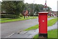
Garnieland Road, Erskine
Looking across the water to Clydebank Town Hall.
Image: © Stephen Sweeney
Taken: 21 Jul 2007
0.20 miles
10
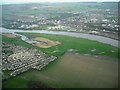
Inner Clyde Nature Reserve
Lies between Erskine and the river
Image: © Jim Smillie
Taken: 7 Apr 2011
0.20 miles