IMAGES TAKEN NEAR TO
Turnhill Gardens, ERSKINE, PA8 7AZ
Introduction
This page details the photographs taken nearby to Turnhill Gardens, PA8 7AZ by members of the Geograph project.
The Geograph project started in 2005 with the aim of publishing, organising and preserving representative images for every square kilometre of Great Britain, Ireland and the Isle of Man.

There are currently over 7.5m images from over14,400 individuals and you can help contribute to the project by visiting https://www.geograph.org.uk
Image Map
Images are licensed for reuse under creativecommons.org/licenses/by-sa/2.0
Notes
- Clicking on the map will re-center to the selected point.
- The higher the marker number, the further away the image location is from the centre of the postcode.
Image Listing (5 Images Found)
Images are licensed for reuse under creativecommons.org/licenses/by-sa/2.0
Image
Details
Distance
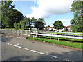
1
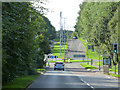
Parkway
Formerly known as Old Greenock Road.
Image: © Thomas Nugent
Taken: 25 Aug 2018
0.21 miles
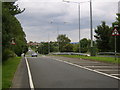
4
Parkway
Looking west from the roundabout at Parksail.
Image: © Thomas Nugent
Taken: 25 Aug 2018
0.24 miles
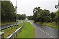
5
Parkway
A short stretch of dual carriageway where the road crosses a footpath south of Park Gate.
Image: © Thomas Nugent
Taken: 25 Aug 2018
0.25 miles