IMAGES TAKEN NEAR TO
Millfield Hill, ERSKINE, PA8 6JN
Introduction
This page details the photographs taken nearby to Millfield Hill, PA8 6JN by members of the Geograph project.
The Geograph project started in 2005 with the aim of publishing, organising and preserving representative images for every square kilometre of Great Britain, Ireland and the Isle of Man.

There are currently over 7.5m images from over14,400 individuals and you can help contribute to the project by visiting https://www.geograph.org.uk
Image Map
Images are licensed for reuse under creativecommons.org/licenses/by-sa/2.0
Notes
- Clicking on the map will re-center to the selected point.
- The higher the marker number, the further away the image location is from the centre of the postcode.
Image Listing (20 Images Found)
Images are licensed for reuse under creativecommons.org/licenses/by-sa/2.0
Image
Details
Distance
1
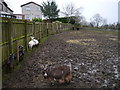
Goats At Lamont City Farm
A view of some of the animals in a heavily poached paddock at Lamont City Farm. Originally opened in 1977, this is the first time I'd visited the farm in over 20 years.
Neighbouring housing in the Millfield estate can be noted in the left of shot.
For more information, see http://lamontfarm.org.uk/
Image: © James T M Towill
Taken: 22 Dec 2011
0.10 miles
2
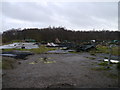
The Remains Of Woodside Riding School
The charred remains of the establishment which appears to have gained substantial press coverage in recent years: http://www.the-gazette.co.uk/news/erskine/articles/2009/08/05/390375-calls-for-action-against-shamed-riding-school/
Image: © James T M Towill
Taken: 22 Dec 2011
0.16 miles
3
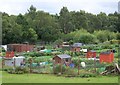
Lamont Gardens Allotments
Allotment gardens near Lamont Farm, Erskine.
Image: © James T M Towill
Taken: 20 Jul 2010
0.16 miles
5
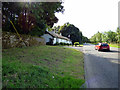
Old Greenock Road
At North Lodge, on the outskirts of Erskine.
Image: © Thomas Nugent
Taken: 25 Aug 2018
0.17 miles
6
The top of Craigend Hill
For an earlier picture, taken from about 70 metres to the north-east, see Image
OS maps give the name as "Craigend Hill", and signs in the area as "Craigends Hill". I would take whichever of the two names locals use to refer to the hill as correct.
Image: © Lairich Rig
Taken: 27 Mar 2017
0.18 miles
7
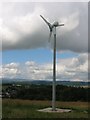
Wind turbine, Craigend
They are usually bigger than this these days. I received a mail from Craig Doogan with further information.
---
The wind turbine is a 2.5 kW wind turbine that is used to provide additional power to St John Bosco's Primary School. The turbine is the first of its kind within Renfrewshire and has proved to be an invaluable resource to provide energy and teach the children about renewable energy.
Image: © Richard Webb
Taken: 26 Jul 2005
0.19 miles
8
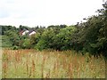
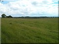
Mature Hawthorn Hedgerow, Craigend Hill
A valuable wildlife habitat, which, prior to the building of the Tilbury Homes estate (in 1990) just visible in the distance, supported a number of bird species such as Yellowhammers.
Image: © James T M Towill
Taken: 20 Jul 2010
0.19 miles
9

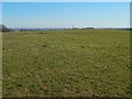
A path on Craigend Hill
A rough path leading to a surfaced path on Craigend Hill. Prior to the early 1990s, this area was cut for hay but is now simply rough grassland.
Image: © James T M Towill
Taken: 28 Sep 2018
0.19 miles