IMAGES TAKEN NEAR TO
Millfield Wynd, ERSKINE, PA8 6JH
Introduction
This page details the photographs taken nearby to Millfield Wynd, PA8 6JH by members of the Geograph project.
The Geograph project started in 2005 with the aim of publishing, organising and preserving representative images for every square kilometre of Great Britain, Ireland and the Isle of Man.

There are currently over 7.5m images from over14,400 individuals and you can help contribute to the project by visiting https://www.geograph.org.uk
Image Map
Images are licensed for reuse under creativecommons.org/licenses/by-sa/2.0
Notes
- Clicking on the map will re-center to the selected point.
- The higher the marker number, the further away the image location is from the centre of the postcode.
Image Listing (7 Images Found)
Images are licensed for reuse under creativecommons.org/licenses/by-sa/2.0
Image
Details
Distance
1
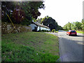
Old Greenock Road
At North Lodge, on the outskirts of Erskine.
Image: © Thomas Nugent
Taken: 25 Aug 2018
0.07 miles
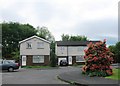
4
West Craigend
Houses on the edge of Erskine.
Image: © Richard Webb
Taken: 2 Jun 2016
0.16 miles
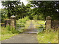
6
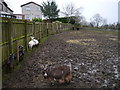
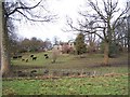
Goats At Lamont City Farm
A view of some of the animals in a heavily poached paddock at Lamont City Farm. Originally opened in 1977, this is the first time I'd visited the farm in over 20 years.
Neighbouring housing in the Millfield estate can be noted in the left of shot.
For more information, see http://lamontfarm.org.uk/
Image: © James T M Towill
Taken: 22 Dec 2011
0.20 miles
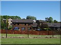
7
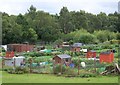
Lamont Gardens Allotments
Allotment gardens near Lamont Farm, Erskine.
Image: © James T M Towill
Taken: 20 Jul 2010
0.24 miles