IMAGES TAKEN NEAR TO
Rashielee Drive, ERSKINE, PA8 6HS
Introduction
This page details the photographs taken nearby to Rashielee Drive, PA8 6HS by members of the Geograph project.
The Geograph project started in 2005 with the aim of publishing, organising and preserving representative images for every square kilometre of Great Britain, Ireland and the Isle of Man.

There are currently over 7.5m images from over14,400 individuals and you can help contribute to the project by visiting https://www.geograph.org.uk
Image Map
Images are licensed for reuse under creativecommons.org/licenses/by-sa/2.0
Notes
- Clicking on the map will re-center to the selected point.
- The higher the marker number, the further away the image location is from the centre of the postcode.
Image Listing (33 Images Found)
Images are licensed for reuse under creativecommons.org/licenses/by-sa/2.0
Image
Details
Distance
2
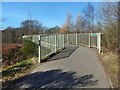
Footbridge over the A726
The steps shown in Image lead here. The small sign, like others nearby, says "Craigends Hill" ("Craigend Hill" on the map).
Image: © Lairich Rig
Taken: 27 Mar 2017
0.07 miles
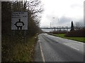
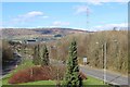
3
Looking south on A726
To the Shell petrol station at Centreholm Roundabout.
Image: © Stephen Sweeney
Taken: 21 Jul 2007
0.07 miles
6
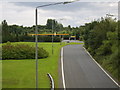
A726 in Erskine
Public holiday, so I was able to take a short cut along the normally busy distribution road through Erskine in comfort. The roundabout ahead has been designed for possible conversion to a split level junction in the future.
Image: © Richard Webb
Taken: 4 Jan 2016
0.09 miles
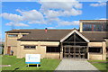
7
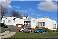
Erskine Church of the Nazarene
Another contributor's earlier picture is a closer view of the building: Image
Image: © Lairich Rig
Taken: 27 Mar 2017
0.09 miles
8
Path to Craigend Hill
The path crosses Rashielee Avenue here, continuing on the other side. The signs along the path consistently use the spelling "Craigends Hill", but maps show "Craigend Hill".
The area extending directly ahead from here was once part of the old Rashielee Quarries, as becomes more obvious further along the path, on the other side of the road: see Image for a view from there, and for further comments. As noted there, a wagonway (a track, probably with rails, for wagons) used to connect those quarries with Rashielee Quay (for which, see Image).
Image: © Lairich Rig
Taken: 27 Mar 2017
0.10 miles
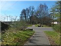
9
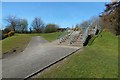
Steps leading to a footbridge
This feature can be seen ahead, from a distance, in Image The steps lead to a Image; the footbridge is marked on the map.
For a view in the opposite direction from the foot of the steps, see Image
Image: © Lairich Rig
Taken: 27 Mar 2017
0.10 miles
10
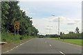
A726 at Erskine
View towards the Erskine Bridge
Image: © Leslie Barrie
Taken: 24 Mar 2014
0.11 miles