IMAGES TAKEN NEAR TO
Glenmoss Avenue, ERSKINE, PA8 6HN
Introduction
This page details the photographs taken nearby to Glenmoss Avenue, PA8 6HN by members of the Geograph project.
The Geograph project started in 2005 with the aim of publishing, organising and preserving representative images for every square kilometre of Great Britain, Ireland and the Isle of Man.

There are currently over 7.5m images from over14,400 individuals and you can help contribute to the project by visiting https://www.geograph.org.uk
Image Map
Images are licensed for reuse under creativecommons.org/licenses/by-sa/2.0
Notes
- Clicking on the map will re-center to the selected point.
- The higher the marker number, the further away the image location is from the centre of the postcode.
Image Listing (19 Images Found)
Images are licensed for reuse under creativecommons.org/licenses/by-sa/2.0
Image
Details
Distance
1
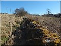
Dry-stone wall
The line of the wall is marked on the 1:25000 map; it is to the west of the summit of Craigend Hill.
Not surprisingly, the wall is also marked on the first-edition map (surveyed in 1857): on Renfrew Sheet VIII.1, it can be seen heading west from a small semicircular copse that has the numeral 46 written in it.
At present, houses in the Linburn area of Erskine are to the south of the wall; some of them can be seen in the right background.
Image: © Lairich Rig
Taken: 27 Mar 2017
0.05 miles
2
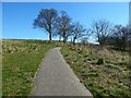
Path on the west side of Craigend Hill
The houses just to the left (south) of the path are in the Linburn area of Erskine.
The central part of the skyline is taken up by (directly behind the people on the path) the broad top of Barscube Hill (Image) and (adjoining it on the right) the area of high ground that is immediately to the NW of the top of that hill (Image).
For a view back up that path, see Image
Image: © Lairich Rig
Taken: 27 Mar 2017
0.06 miles
3
Path on the west side of Craigend Hill
This is a view uphill; for a view back down the path from a point a little further uphill, see Image
Image: © Lairich Rig
Taken: 27 Mar 2017
0.09 miles
4

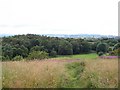
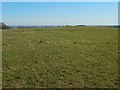
A path on Craigend Hill
A rough path leading to a surfaced path on Craigend Hill. Prior to the early 1990s, this area was cut for hay but is now simply rough grassland.
Image: © James T M Towill
Taken: 28 Sep 2018
0.10 miles
5
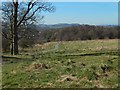
A View To Linburn Wood
A view of a small wood, known as Linburn Wood, from Craigend Hill. The footpath links the former Scottish Special Housing Association (SSHA) area of Erskine with the private housing of Linburn. This small wood hosts a range of wildlife including many bird species and the common weekend organism Teenagerus drunkus.
Image: © James T M Towill
Taken: 20 Jul 2010
0.11 miles
6
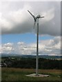
Wind turbine, Craigend
They are usually bigger than this these days. I received a mail from Craig Doogan with further information.
---
The wind turbine is a 2.5 kW wind turbine that is used to provide additional power to St John Bosco's Primary School. The turbine is the first of its kind within Renfrewshire and has proved to be an invaluable resource to provide energy and teach the children about renewable energy.
Image: © Richard Webb
Taken: 26 Jul 2005
0.12 miles
7
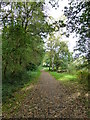
Path at Linburn Wood
A path linking Linburn with Bargarran in Erskine. The wood is known as Linburn Wood, but is actually the easternmost extent of the former Shilton Plantation.
Image: © James T M Towill
Taken: 28 Sep 2018
0.13 miles
8
The top of Craigend Hill
For an earlier picture, taken from about 70 metres to the north-east, see Image
OS maps give the name as "Craigend Hill", and signs in the area as "Craigends Hill". I would take whichever of the two names locals use to refer to the hill as correct.
Image: © Lairich Rig
Taken: 27 Mar 2017
0.13 miles
9
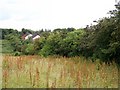
Mature Hawthorn Hedgerow, Craigend Hill
A valuable wildlife habitat, which, prior to the building of the Tilbury Homes estate (in 1990) just visible in the distance, supported a number of bird species such as Yellowhammers.
Image: © James T M Towill
Taken: 20 Jul 2010
0.13 miles
10
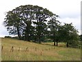
Craigend Hill Trees
A small stand of Sycamore and Beech trees on Craigend Hill.
Image: © James T M Towill
Taken: 20 Jul 2010
0.13 miles