IMAGES TAKEN NEAR TO
Newburgh, ERSKINE, PA8 6EG
Introduction
This page details the photographs taken nearby to Newburgh, PA8 6EG by members of the Geograph project.
The Geograph project started in 2005 with the aim of publishing, organising and preserving representative images for every square kilometre of Great Britain, Ireland and the Isle of Man.

There are currently over 7.5m images from over14,400 individuals and you can help contribute to the project by visiting https://www.geograph.org.uk
Image Map
Images are licensed for reuse under creativecommons.org/licenses/by-sa/2.0
Notes
- Clicking on the map will re-center to the selected point.
- The higher the marker number, the further away the image location is from the centre of the postcode.
Image Listing (10 Images Found)
Images are licensed for reuse under creativecommons.org/licenses/by-sa/2.0
Image
Details
Distance
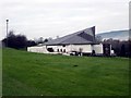
1
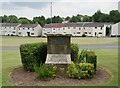
Commemorative stone adjacent to Blantyre Court, Erskine
A commemorative stone adjacent to Blantyre Court, Bargarran (behind the photographer) with a view across Barhill Road to Findochty, North Barr.
The plaque at the top of the commemorative stone has the following inscription:
HER MAJESTY THE QUEEN
AND
HIS ROYAL HIGHNESS THE DUKE OF EDINBURGH
HONOURED THE NEW TOWN OF ERSKINE
BY VISITING IT ON 3RD JULY 1974
WHEN HER MAJESTY UNVEILED THIS COMMEMORATIVE STONE
Image: © James T M Towill
Taken: 2 Jul 2021
0.15 miles
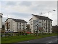
2
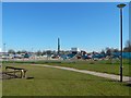
North Barr and Rashielee
Looking across the A726 towards new housing on Barrholm Drive.
Image: © M J Richardson
Taken: 24 Apr 2014
0.15 miles
4
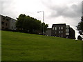
Bargarran, Erskine
Houses in the estate in Erskine.
Image: © Stephen Sweeney
Taken: 21 Jul 2007
0.16 miles
5
St. John Bosco Roman Catholic Church in Erskine
Image: © James Denham
Taken: 24 Nov 2013
0.20 miles
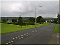
6
Flats, Barholm Crescent
The A726, a distribution road for Erskine was quiet and easy to use on a public holiday.
Image: © Richard Webb
Taken: 4 Jan 2016
0.20 miles
7
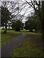
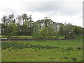
A Footpath In Parkland At Rashielee
A footpath leading through municipal parkland in Rashielee. The houses to the left are in the street called Balmedie.
Image: © James T M Towill
Taken: 22 Dec 2011
0.22 miles
8

Pandamonium Play Centre sign, Rashielee, Erskine
Image: © Leslie Barrie
Taken: 24 Mar 2014
0.24 miles
9
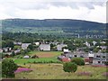
Bargarran, Erskine
A view of the Bargarran community area of Erskine, from Craigend Hill. Terraced housing to the left is part of Allison Avenue, the multi-storey flats to the right form Shaw Court. St John Bosco Primary School is to the foreground, Bargarran Primary School behind it and finally Bargarran Shopping Centre. The Erskine Bridge with a backdrop of the Kilpatrick Hills is prominent in the distance.
Image: © James T M Towill
Taken: 20 Jul 2010
0.24 miles
10
Construction site beside Barhill Road
The path in the foreground is shown in Image, and is a continuation of the one shown in Image; between there and here, it crosses a road: Image
On the construction site visible ahead, two primary schools (Bargarran and St John Bosco Primary Schools) have been demolished, to be replaced by a joint campus primary school and a nursery.
Image: © Lairich Rig
Taken: 27 Mar 2017
0.25 miles