IMAGES TAKEN NEAR TO
Findhorn, ERSKINE, PA8 6DX
Introduction
This page details the photographs taken nearby to Findhorn, PA8 6DX by members of the Geograph project.
The Geograph project started in 2005 with the aim of publishing, organising and preserving representative images for every square kilometre of Great Britain, Ireland and the Isle of Man.

There are currently over 7.5m images from over14,400 individuals and you can help contribute to the project by visiting https://www.geograph.org.uk
Image Map
Images are licensed for reuse under creativecommons.org/licenses/by-sa/2.0
Notes
- Clicking on the map will re-center to the selected point.
- The higher the marker number, the further away the image location is from the centre of the postcode.
Image Listing (8 Images Found)
Images are licensed for reuse under creativecommons.org/licenses/by-sa/2.0
Image
Details
Distance
1
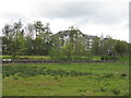
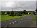
North Barr and Rashielee
Looking across the A726 towards new housing on Barrholm Drive.
Image: © M J Richardson
Taken: 24 Apr 2014
0.13 miles
2
Bargarran, Erskine
Houses in the estate in Erskine.
Image: © Stephen Sweeney
Taken: 21 Jul 2007
0.15 miles
3
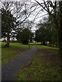
A Footpath In Parkland At Rashielee
A footpath leading through municipal parkland in Rashielee. The houses to the left are in the street called Balmedie.
Image: © James T M Towill
Taken: 22 Dec 2011
0.17 miles
4
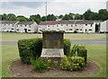
Commemorative stone adjacent to Blantyre Court, Erskine
A commemorative stone adjacent to Blantyre Court, Bargarran (behind the photographer) with a view across Barhill Road to Findochty, North Barr.
The plaque at the top of the commemorative stone has the following inscription:
HER MAJESTY THE QUEEN
AND
HIS ROYAL HIGHNESS THE DUKE OF EDINBURGH
HONOURED THE NEW TOWN OF ERSKINE
BY VISITING IT ON 3RD JULY 1974
WHEN HER MAJESTY UNVEILED THIS COMMEMORATIVE STONE
Image: © James T M Towill
Taken: 2 Jul 2021
0.20 miles
5

Parkland In Rashielee
An area of municipal parkland between Barhill Road and Rashielee Road, adjoined by the streets of Balmedie and Rashielee. This is the district of Erskine known as Rashielee, part of the original Scottish Special Housing Association (SSHA) development from the 1970s.
Image: © James T M Towill
Taken: 22 Dec 2011
0.21 miles
6

Pandamonium Play Centre sign, Rashielee, Erskine
Image: © Leslie Barrie
Taken: 24 Mar 2014
0.22 miles
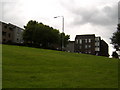
8
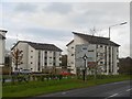
Flats, Barholm Crescent
The A726, a distribution road for Erskine was quiet and easy to use on a public holiday.
Image: © Richard Webb
Taken: 4 Jan 2016
0.24 miles