IMAGES TAKEN NEAR TO
Lochy Place, ERSKINE, PA8 6AY
Introduction
This page details the photographs taken nearby to Lochy Place, PA8 6AY by members of the Geograph project.
The Geograph project started in 2005 with the aim of publishing, organising and preserving representative images for every square kilometre of Great Britain, Ireland and the Isle of Man.

There are currently over 7.5m images from over14,400 individuals and you can help contribute to the project by visiting https://www.geograph.org.uk
Image Map
Images are licensed for reuse under creativecommons.org/licenses/by-sa/2.0
Notes
- Clicking on the map will re-center to the selected point.
- The higher the marker number, the further away the image location is from the centre of the postcode.
Image Listing (27 Images Found)
Images are licensed for reuse under creativecommons.org/licenses/by-sa/2.0
Image
Details
Distance
1
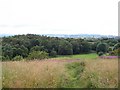
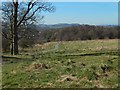
A View To Linburn Wood
A view of a small wood, known as Linburn Wood, from Craigend Hill. The footpath links the former Scottish Special Housing Association (SSHA) area of Erskine with the private housing of Linburn. This small wood hosts a range of wildlife including many bird species and the common weekend organism Teenagerus drunkus.
Image: © James T M Towill
Taken: 20 Jul 2010
0.13 miles
2
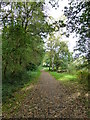
Path at Linburn Wood
A path linking Linburn with Bargarran in Erskine. The wood is known as Linburn Wood, but is actually the easternmost extent of the former Shilton Plantation.
Image: © James T M Towill
Taken: 28 Sep 2018
0.15 miles
3
Linburn Road
Off Old Greenock Road, which is in the foroeground.
Image: © Thomas Nugent
Taken: 25 Aug 2018
0.16 miles
5
Path on the west side of Craigend Hill
The houses just to the left (south) of the path are in the Linburn area of Erskine.
The central part of the skyline is taken up by (directly behind the people on the path) the broad top of Barscube Hill (Image) and (adjoining it on the right) the area of high ground that is immediately to the NW of the top of that hill (Image).
For a view back up that path, see Image
Image: © Lairich Rig
Taken: 27 Mar 2017
0.19 miles
6
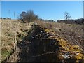
Dry-stone wall
The line of the wall is marked on the 1:25000 map; it is to the west of the summit of Craigend Hill.
Not surprisingly, the wall is also marked on the first-edition map (surveyed in 1857): on Renfrew Sheet VIII.1, it can be seen heading west from a small semicircular copse that has the numeral 46 written in it.
At present, houses in the Linburn area of Erskine are to the south of the wall; some of them can be seen in the right background.
Image: © Lairich Rig
Taken: 27 Mar 2017
0.20 miles
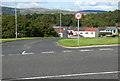
7
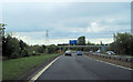
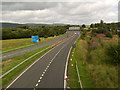
M898 southbound approaching the M8 split for east and west
Image: © John Firth
Taken: 11 May 2012
0.20 miles
8
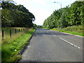
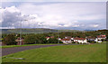
Old Greenock Road
Looking west at West Craigend.
Image: © Thomas Nugent
Taken: 25 Aug 2018
0.20 miles
9
M898 looking North
From Old Greenock Road.
Image: © Stephen Sweeney
Taken: 4 Aug 2007
0.20 miles
10
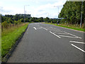
Old Greenock Road
Hatch marks at the Linburn Road junction.
Image: © Thomas Nugent
Taken: 25 Aug 2018
0.21 miles