IMAGES TAKEN NEAR TO
Barrhill Road, ERSKINE, PA8 6AG
Introduction
This page details the photographs taken nearby to Barrhill Road, PA8 6AG by members of the Geograph project.
The Geograph project started in 2005 with the aim of publishing, organising and preserving representative images for every square kilometre of Great Britain, Ireland and the Isle of Man.

There are currently over 7.5m images from over14,400 individuals and you can help contribute to the project by visiting https://www.geograph.org.uk
Image Map
Images are licensed for reuse under creativecommons.org/licenses/by-sa/2.0
Notes
- Clicking on the map will re-center to the selected point.
- The higher the marker number, the further away the image location is from the centre of the postcode.
Image Listing (24 Images Found)
Images are licensed for reuse under creativecommons.org/licenses/by-sa/2.0
Image
Details
Distance
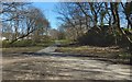
1

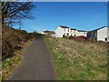
Parkland In Rashielee
An area of municipal parkland between Barhill Road and Rashielee Road, adjoined by the streets of Balmedie and Rashielee. This is the district of Erskine known as Rashielee, part of the original Scottish Special Housing Association (SSHA) development from the 1970s.
Image: © James T M Towill
Taken: 22 Dec 2011
0.04 miles
2
Path on east side of Craigend Hill
Local signage consistently uses the spelling "Craigends Hill", and OS maps call it "Craigend Hill".
The houses are on various small inshots (as we say in these parts) off Barhill Road; the nearer inshot is called Burnhaven, with Portessie a little further away.
Image: © Lairich Rig
Taken: 27 Mar 2017
0.06 miles
3

The New Park Mains High School
Part of Renfrewshire Council's 'Building Better Communities' programme, the new £33 million High School for the town and surrounding villages will open in August 2012 and will replace the original school, built in the 1970s.
Image: © James T M Towill
Taken: 22 Dec 2011
0.07 miles
4
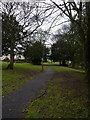
A Footpath In Parkland At Rashielee
A footpath leading through municipal parkland in Rashielee. The houses to the left are in the street called Balmedie.
Image: © James T M Towill
Taken: 22 Dec 2011
0.09 miles
5
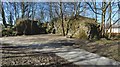
Path through the old Rashielee Quarries
A straight path (whose western part is shown entering at the bottom right of the picture) here runs parallel to the line of the former Rashielee Quarries; some of the rock faces of those quarries can be seen ahead.
(For a view in the opposite direction from about the same place, showing another rock face, see Image See also Image, a continuation of that path.)
They were described in the OS Name Books of 1856—57 as "an extensive whinstone quarry, the property of John Henderson Esq."; the 1895 revision of the map labels them "disused".
John F Riddell, in his 1979 book "Clyde Navigation", mentions that the stone from the Rashielee workings was derived from the lava flows that make up the Renfrewshire Hills, and that it was used for, amongst other things, an extension made to Image "during the first decade of the nineteenth century", and to provide the facing of other training walls in the River Clyde, to protect the banks from erosion.
In fact, as he says, the stone "was used throughout the river"; he also notes that "a quay was constructed at Rashielie so that the stone could be loaded into barges more easily", and that a length of wagonway connected the quay with the quarry. See also Image
The wagonway itself can be seen on the first-edition map, surveyed in 1857.
When the map was revised in 1895, the quarries were disused, and the track connecting them to the quay no longer existed, but map evidence of features related to that track lingered: specifically, the 1895 map shows some isolated cuttings; they were made during the formation of that track.
Without knowledge of the former existence of the wagonway, the appearance of those cuttings on the map would be puzzling.
Image: © Lairich Rig
Taken: 27 Mar 2017
0.13 miles
6
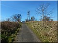
Path to the top of Craigend Hill
The path and the mast that can be seen ahead are marked on the 1:25000 map. For a closer view of the mast, see Image
Image: © Lairich Rig
Taken: 27 Mar 2017
0.14 miles
7
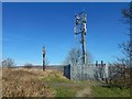
Mast on Craigend Hill
The mast is marked on the 1:25000 map. For the path leading here from the east (the right), see Image
Image: © Lairich Rig
Taken: 27 Mar 2017
0.15 miles
8
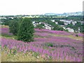
Rashielee
Housing area in Erskine. Some land yet to be built upon.
Image: © Richard Webb
Taken: 26 Jul 2005
0.15 miles
9
Path through the old Rashielee Quarries
The view is from about the same point as Image, but in the opposite direction. The rock face on the right in the present picture is another reminder of the former presence of those quarries. See the link just given for further information.
When followed in the view direction of the present picture, the path meets and crosses a road; see Image for a view back from the other side of that road.
Image: © Lairich Rig
Taken: 27 Mar 2017
0.17 miles
10
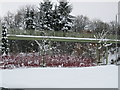
Footpath bridge at Rashielee, Erskine.
Image: © Johnny Durnan
Taken: 12 Mar 2006
0.17 miles