IMAGES TAKEN NEAR TO
Morvern, OBAN, PA80 5XD
Introduction
This page details the photographs taken nearby to PA80 5XD by members of the Geograph project.
The Geograph project started in 2005 with the aim of publishing, organising and preserving representative images for every square kilometre of Great Britain, Ireland and the Isle of Man.

There are currently over 7.5m images from over14,400 individuals and you can help contribute to the project by visiting https://www.geograph.org.uk
Image Map
Images are licensed for reuse under creativecommons.org/licenses/by-sa/2.0
Notes
- Clicking on the map will re-center to the selected point.
- The higher the marker number, the further away the image location is from the centre of the postcode.
Image Listing (13 Images Found)
Images are licensed for reuse under creativecommons.org/licenses/by-sa/2.0
Image
Details
Distance
2
Clounlaid
The cottage of Clounlaid on the A884.
Image: © Colin Kinnear
Taken: 5 Jun 2009
0.01 miles
4
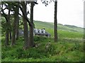
Clounlaid
The remote house of Clounlaid is a landmark on the road to Lochaline.
Image: © John Allan
Taken: 1 Jul 2006
0.03 miles

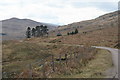
6
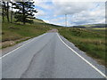
Road (A884) near to Clounlaid
Looking north-eastward.
Image: © Peter Wood
Taken: 29 May 2019
0.04 miles


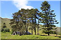
10
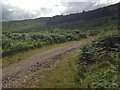
Small fenced area of forestry near Clounlaid
Image: © Steven Brown
Taken: 2 Oct 2022
0.12 miles