IMAGES TAKEN NEAR TO
Heylipol, ISLE OF TIREE, PA77 6TY
Introduction
This page details the photographs taken nearby to PA77 6TY by members of the Geograph project.
The Geograph project started in 2005 with the aim of publishing, organising and preserving representative images for every square kilometre of Great Britain, Ireland and the Isle of Man.

There are currently over 7.5m images from over14,400 individuals and you can help contribute to the project by visiting https://www.geograph.org.uk
Image Map
Images are licensed for reuse under creativecommons.org/licenses/by-sa/2.0
Notes
- Clicking on the map will re-center to the selected point.
- The higher the marker number, the further away the image location is from the centre of the postcode.
Image Listing (4 Images Found)
Images are licensed for reuse under creativecommons.org/licenses/by-sa/2.0
Image
Details
Distance
1
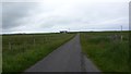
Single track road
The B8065 passes through Heylipol on the Isle of Tiree.
Image: © Peter Mackenzie
Taken: 22 Jun 2017
0.17 miles
2
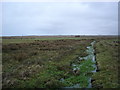
Crofting land near Heylipol
Cattle grazing in the field, and there were loads of geese! The waterway looks like drainage as it is suspiciously straight.
Image: © Roger McLachlan
Taken: 8 Jan 2007
0.17 miles
4
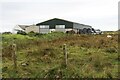
Small farm building at Heylipol
The level interior of the Isle of Tiree stretches into the distance.
Image: © Oliver Dixon
Taken: 13 Aug 2009
0.22 miles