IMAGES TAKEN NEAR TO
Ulva Ferry, ISLE OF MULL, PA73 6LX
Introduction
This page details the photographs taken nearby to PA73 6LX by members of the Geograph project.
The Geograph project started in 2005 with the aim of publishing, organising and preserving representative images for every square kilometre of Great Britain, Ireland and the Isle of Man.

There are currently over 7.5m images from over14,400 individuals and you can help contribute to the project by visiting https://www.geograph.org.uk
Image Map
Images are licensed for reuse under creativecommons.org/licenses/by-sa/2.0
Notes
- Clicking on the map will re-center to the selected point.
- The higher the marker number, the further away the image location is from the centre of the postcode.
Image Listing (6 Images Found)
Images are licensed for reuse under creativecommons.org/licenses/by-sa/2.0
Image
Details
Distance
1
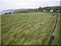
Grassy Fanmore field with tilted fence
Image: © C Michael Hogan
Taken: 7 Jul 2010
0.13 miles
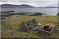
2
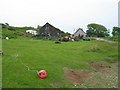
Fisherman's house at Fanmore
With a garden full of lobster pots.
Image: © John Allan
Taken: 4 Jul 2006
0.20 miles
4
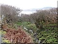
Hazel wood
The partial shelter of a watercourse enables some woodland to get established.
Image: © Richard Webb
Taken: 14 Apr 2011
0.22 miles
5
The Mull coast
The ever changing and very varied coast line of Mull is worth the visit to the island alone.
Image: © Malcolm Neal
Taken: 3 May 2015
0.23 miles
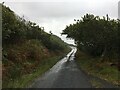
6
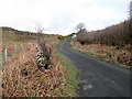
B8073
A singletrack road running around the northwest coast of Mull.
Image: © Richard Webb
Taken: 14 Apr 2011
0.24 miles