IMAGES TAKEN NEAR TO
Aros, ISLE OF MULL, PA72 6JY
Introduction
This page details the photographs taken nearby to PA72 6JY by members of the Geograph project.
The Geograph project started in 2005 with the aim of publishing, organising and preserving representative images for every square kilometre of Great Britain, Ireland and the Isle of Man.

There are currently over 7.5m images from over14,400 individuals and you can help contribute to the project by visiting https://www.geograph.org.uk
Image Map
Images are licensed for reuse under creativecommons.org/licenses/by-sa/2.0
Notes
- Clicking on the map will re-center to the selected point.
- The higher the marker number, the further away the image location is from the centre of the postcode.
Image Listing (6 Images Found)
Images are licensed for reuse under creativecommons.org/licenses/by-sa/2.0
Image
Details
Distance
1
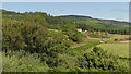
Kellan
Seen from a car park overlooking Loch na Keal.
Image: © Richard Webb
Taken: 2 Aug 2021
0.06 miles
2
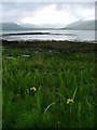
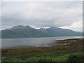
Loch na Keal
From the north shore near Kellan Old Farm to Glen Ba.
Image: © Mick Garratt
Taken: 3 Jun 2006
0.12 miles
3
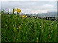
North shore of Loch na Keal
Taken just west of the entrance to Kellan Old Farm.
Image: © Mick Garratt
Taken: 3 Jun 2006
0.17 miles
4
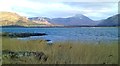
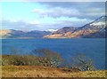
Reedbeds at the lochside
Looking across Loch na Keal towards the low ground at the foot of Loch Ba, with the central mountains of Mull beyond.
Image: © Gordon Hatton
Taken: 25 Mar 2013
0.19 miles
6
On the shores of Loch na Keal
Looking east across the loch towards Gruline. The snowy peak to the right is Beinn a Ghraig.
Image: © Gordon Hatton
Taken: 25 Mar 2013
0.25 miles