IMAGES TAKEN NEAR TO
Pennyghael, ISLE OF MULL, PA70 6HG
Introduction
This page details the photographs taken nearby to PA70 6HG by members of the Geograph project.
The Geograph project started in 2005 with the aim of publishing, organising and preserving representative images for every square kilometre of Great Britain, Ireland and the Isle of Man.

There are currently over 7.5m images from over14,400 individuals and you can help contribute to the project by visiting https://www.geograph.org.uk
Image Map
Images are licensed for reuse under creativecommons.org/licenses/by-sa/2.0
Notes
- Clicking on the map will re-center to the selected point.
- The higher the marker number, the further away the image location is from the centre of the postcode.
Image Listing (15 Images Found)
Images are licensed for reuse under creativecommons.org/licenses/by-sa/2.0
Image
Details
Distance
1
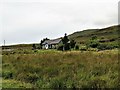
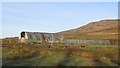
Cottage at Uluvalt
A cottage by the A849 at Uluvalt.
Image: © Andrew Wood
Taken: 30 Aug 2018
0.00 miles
3
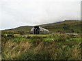
Nissen Hut at Uluvalt
A hut in use in the smallholding at Uluvalt.
Image: © Andrew Wood
Taken: 30 Aug 2018
0.02 miles
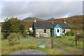
4
Uluvalt
Farmland at the foot of Glen More. The old B8035 road is in the foreground.
Image: © Richard Webb
Taken: 15 Apr 2014
0.04 miles
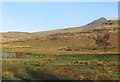
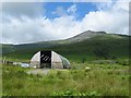
5
Uluvalt
Nissen hut byre and gathering pens in Glen More.
Image: © Richard Webb
Taken: 15 Apr 2014
0.06 miles
6
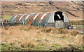
Corrugated metal building near to Uluvalt
A 'nissen hut' type building beside the A849 close to the head of Loch Scridain.
Image: © Trevor Littlewood
Taken: 23 Apr 2015
0.06 miles
8
Barn at Uluvalt
At the west end of Glen More.
Image: © John Allan
Taken: 7 Jul 2006
0.11 miles
9
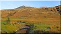
Achadh an Aodainn
Mist clears from Ben More.
Image: © Richard Webb
Taken: 15 Apr 2014
0.11 miles
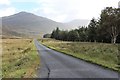
10
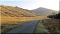
Glen More
View up the A849 towards Corra-bheinn.
Image: © Richard Webb
Taken: 15 Apr 2014
0.12 miles