IMAGES TAKEN NEAR TO
Dunlin Crescent, JOHNSTONE, PA6 7JX
Introduction
This page details the photographs taken nearby to Dunlin Crescent, PA6 7JX by members of the Geograph project.
The Geograph project started in 2005 with the aim of publishing, organising and preserving representative images for every square kilometre of Great Britain, Ireland and the Isle of Man.

There are currently over 7.5m images from over14,400 individuals and you can help contribute to the project by visiting https://www.geograph.org.uk
Image Map
Images are licensed for reuse under creativecommons.org/licenses/by-sa/2.0
Notes
- Clicking on the map will re-center to the selected point.
- The higher the marker number, the further away the image location is from the centre of the postcode.
Image Listing (9 Images Found)
Images are licensed for reuse under creativecommons.org/licenses/by-sa/2.0
Image
Details
Distance
6
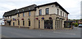
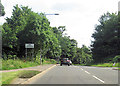
The River Inn, Crosslee
The much modified, modernised and extended former Crosslee Inn and Pine Trees.
Web site: https://riverinn.co.uk/#home .
Image: © Thomas Nugent
Taken: 7 Sep 2018
0.23 miles
7
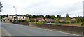
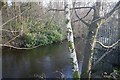
Crosslee Bridge
Carries the B789 Barochan Road over the River Gryffe. The road becomes Houston Road beyond the bridge, becoming Barochan Road again on the other side of Houston.
Image: © Thomas Nugent
Taken: 7 Sep 2018
0.24 miles
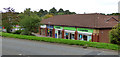
8
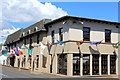
Shops at Houston
The largest being the Cooperative.
Image: © Thomas Nugent
Taken: 7 Sep 2018
0.25 miles
9
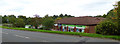
Shops at Houston
The largest being the Cooperative, which occupies several units.
Image: © Thomas Nugent
Taken: 7 Sep 2018
0.25 miles