IMAGES TAKEN NEAR TO
Lyles Land, JOHNSTONE, PA6 7JA
Introduction
This page details the photographs taken nearby to Lyles Land, PA6 7JA by members of the Geograph project.
The Geograph project started in 2005 with the aim of publishing, organising and preserving representative images for every square kilometre of Great Britain, Ireland and the Isle of Man.

There are currently over 7.5m images from over14,400 individuals and you can help contribute to the project by visiting https://www.geograph.org.uk
Image Map
Images are licensed for reuse under creativecommons.org/licenses/by-sa/2.0
Notes
- Clicking on the map will re-center to the selected point.
- The higher the marker number, the further away the image location is from the centre of the postcode.
Image Listing (51 Images Found)
Images are licensed for reuse under creativecommons.org/licenses/by-sa/2.0
Image
Details
Distance
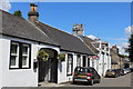
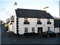
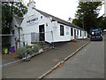
2
Houston Inn, North Street, Houston
Dated 1784
Image: © Leslie Barrie
Taken: 6 Jul 2014
0.07 miles
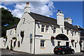
3
The Houston Inn
On North Street at Main Street, which is in the foreground.
Image: © Thomas Nugent
Taken: 7 Sep 2018
0.07 miles
4
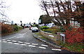
Fields Lane
Off Kilmacolm Road in Houston.
Image: © Thomas Nugent
Taken: 8 Nov 2018
0.07 miles
5
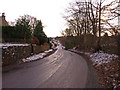
Houston, B789
Looking down the hill from the War Memorial towards the village.
Image: © wfmillar
Taken: 20 Dec 2009
0.07 miles
6
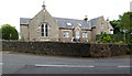
The Old School House
A former school on the bend on the B789 Barochan Road near Houston war memorial.
Image: © Thomas Nugent
Taken: 7 Sep 2018
0.08 miles
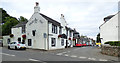
9
Main Street bar & grill
On Main Street, Houston. Appears to be shut down.
Image: © Thomas Nugent
Taken: 7 Sep 2018
0.09 miles
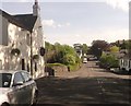
10
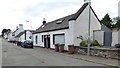
South Street, Houston
One side of this cottage appears to have been a shop in the recent past.
Image: © Thomas Nugent
Taken: 7 Sep 2018
0.09 miles