IMAGES TAKEN NEAR TO
Chapel Road, JOHNSTONE, PA6 7AX
Introduction
This page details the photographs taken nearby to Chapel Road, PA6 7AX by members of the Geograph project.
The Geograph project started in 2005 with the aim of publishing, organising and preserving representative images for every square kilometre of Great Britain, Ireland and the Isle of Man.

There are currently over 7.5m images from over14,400 individuals and you can help contribute to the project by visiting https://www.geograph.org.uk
Image Map
Images are licensed for reuse under creativecommons.org/licenses/by-sa/2.0
Notes
- Clicking on the map will re-center to the selected point.
- The higher the marker number, the further away the image location is from the centre of the postcode.
Image Listing (6 Images Found)
Images are licensed for reuse under creativecommons.org/licenses/by-sa/2.0
Image
Details
Distance
2
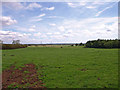
Field at Chapel Farm
Looking towards Paisley.
Image: © wfmillar
Taken: 14 Jun 2011
0.11 miles
3
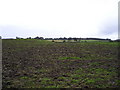
Cabbage Stumps
Field of cabbage stumps remaining after the cabbages were harvested. The hedge line in the middle ground marks Barochan road, with Cleaves Wood on the hill in the background.
Image: © Chris Court
Taken: 30 Sep 2005
0.15 miles
4
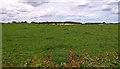
Fields near Chapel Farm
Hawthorn hedge in the foreground.
Image: © wfmillar
Taken: 14 Jun 2011
0.16 miles
5

Rough road to Barochan Gatehouse
Beech trees it make look like Autumn but this is June. We had bad storms in May and the trees got blasted.
Image: © wfmillar
Taken: 14 Jun 2011
0.24 miles
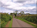
6
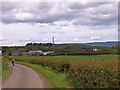
Looking towards Chapel Farm
Minor road good for walkers and cyclists.
Image: © wfmillar
Taken: 14 Jun 2011
0.25 miles