IMAGES TAKEN NEAR TO
Bunessan, ISLE OF MULL, PA67 6DT
Introduction
This page details the photographs taken nearby to PA67 6DT by members of the Geograph project.
The Geograph project started in 2005 with the aim of publishing, organising and preserving representative images for every square kilometre of Great Britain, Ireland and the Isle of Man.

There are currently over 7.5m images from over14,400 individuals and you can help contribute to the project by visiting https://www.geograph.org.uk
Image Map
Images are licensed for reuse under creativecommons.org/licenses/by-sa/2.0
Notes
- Clicking on the map will re-center to the selected point.
- The higher the marker number, the further away the image location is from the centre of the postcode.
Image Listing (34 Images Found)
Images are licensed for reuse under creativecommons.org/licenses/by-sa/2.0
Image
Details
Distance
1
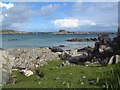
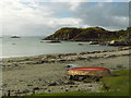
Port Uisken, Mull
Coastline at Uisken on the south side of the Ross of Mull
Image: © Bob Jones
Taken: 21 May 2003
0.04 miles
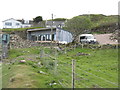
2
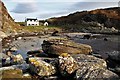
Ardchiavaig
Coastal property amongst the usual wet grassland.
Image: © Richard Webb
Taken: 10 Apr 2007
0.04 miles
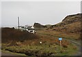
3
New house building at Ardchiavaig
Almost on the shore, so it will have a good seaview.
Image: © M J Richardson
Taken: 22 May 2019
0.05 miles
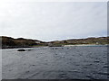
8
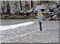
Uisken from the beach
The beach is sandy, with rocks at either end.
Image: © Richard Dorrell
Taken: 12 Nov 2008
0.10 miles
10
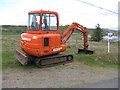
Mini-excavator at Uisken
A Daewoo SOLAR 030 Plus. Handy equipment for this part of the world.
Image: © M J Richardson
Taken: 22 May 2019
0.11 miles