IMAGES TAKEN NEAR TO
Church Brae, ISLE OF MULL, PA67 6DB
Introduction
This page details the photographs taken nearby to Church Brae, PA67 6DB by members of the Geograph project.
The Geograph project started in 2005 with the aim of publishing, organising and preserving representative images for every square kilometre of Great Britain, Ireland and the Isle of Man.

There are currently over 7.5m images from over14,400 individuals and you can help contribute to the project by visiting https://www.geograph.org.uk
Image Map (Loading...)


Getting Data...Please wait
Leaflet Map data © OpenStreetMap
Images are licensed for reuse under creativecommons.org/licenses/by-sa/2.0
Notes
- Clicking on the map will re-center to the selected point.
- The higher the marker number, the further away the image location is from the centre of the postcode.
Image Listing (53 Images Found)
Images are licensed for reuse under creativecommons.org/licenses/by-sa/2.0
Image
Details
Distance
1
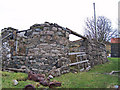
Ruined barn, Bunessan
Buildings with rounded corners generally pre-date square cornered structures, so this may well be one of the oldest buildings in Bunessan village.
The rusting engine parts in the foreground look quite interesting too!
Image: © Richard Dorrell
Taken: 12 Nov 2008
0.02 miles
2
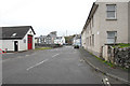
Bunessan main road
A849 road through Bunessan. Fire station on left.
Image: © Peter Amsden
Taken: 28 Sep 2009
0.03 miles
3
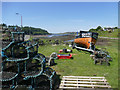
Lobster fishing paraphernalia at Bunessan
The trailer (and Landrover, out of shot) are clearly needed as the tide goes out leaving drying mud flats for half a kilometre from here (which is why Bunessan Pier is a kilometre west of the village). There seem to be plenty of spare pots here, but no buoys - there's a limited number of spots to put them, so spares go on existing buoys when damaged pots are pulled up.
Image: © Andy Waddington
Taken: 28 May 2018
0.04 miles
5
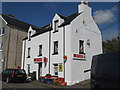
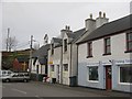
Spar and Post Office at Bunessan
Stockists of all essential supplies.
Image: © M J Richardson
Taken: 8 May 2012
0.04 miles
7
Bunessan Parish Church
The church dates from 1804; some of the stone used in its construction was taken from the ruins of a mediaeval church at Kilvickeon Image
Image: © Robert Struthers
Taken: 8 Apr 2015
0.05 miles
8
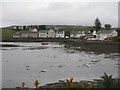
Bunessan, from across the bay
Bordering an inlet of Loch Scridain on the A849.
Image: © M J Richardson
Taken: 23 May 2019
0.05 miles
9
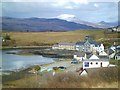
Bunessan
The largest settlement on the Ross of Mull. A view of the village from the road past the police house. A snow capped Ben More in the distance, with the conical Cruachan Dearg to the right.
Image: © Gordon Hatton
Taken: 26 Mar 2013
0.05 miles
10
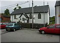
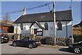
Bunessan Church Of Scotland / Kilvickeon Kirk
Image: © J M Briscoe
Taken: 23 Jun 2005
0.06 miles