IMAGES TAKEN NEAR TO
ISLE OF COLONSAY, PA61 7YR
Introduction
This page details the photographs taken nearby to PA61 7YR by members of the Geograph project.
The Geograph project started in 2005 with the aim of publishing, organising and preserving representative images for every square kilometre of Great Britain, Ireland and the Isle of Man.

There are currently over 7.5m images from over14,400 individuals and you can help contribute to the project by visiting https://www.geograph.org.uk
Image Map
Images are licensed for reuse under creativecommons.org/licenses/by-sa/2.0
Notes
- Clicking on the map will re-center to the selected point.
- The higher the marker number, the further away the image location is from the centre of the postcode.
Image Listing (20 Images Found)
Images are licensed for reuse under creativecommons.org/licenses/by-sa/2.0
Image
Details
Distance
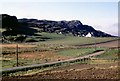
2
Standing stones at Kilchattan
The nearest is in square [NR3694], the other just in the next square north [NR3695].
Image: © M J Richardson
Taken: 6 May 2014
0.05 miles
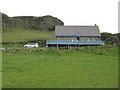
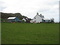
3
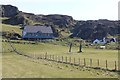
Standing stones at Kilchattan
Looking north to houses on the B8086 at Kilchattan.
Image: © M J Richardson
Taken: 6 May 2014
0.05 miles
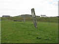
5
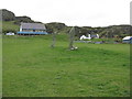
Standing stones at Kilchattan
With newer structures beyond. The nearest is in this square [NR3695], the other in the adjacent square [NR3694].
Image: © M J Richardson
Taken: 6 May 2014
0.05 miles
6
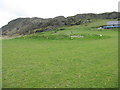
Mound of stones
Adjacent to the two standing stones at Kilchattan - maybe the remains of a structure associated with them, or just a heap of stone.
Image: © M J Richardson
Taken: 6 May 2014
0.06 miles
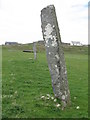
7
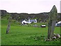
Fingal's Limpet Hammers
A pair of tall and leaning standing stones colloquially named after implements used for prising limpets from the rocks. Probably a food source used locally since the Island was first colonised.
Image: © Andrew Curtis
Taken: 29 May 2008
0.06 miles
8
Standing stones
At Lower Kilchattan, under Carn Mor.
Image: © Russel Wills
Taken: 27 Mar 2017
0.07 miles
9
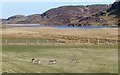
Greylag geese at Lower Kilchattan
Loch Fada, a fishing loch, in the distance.
Image: © Russel Wills
Taken: 27 Mar 2017
0.10 miles