IMAGES TAKEN NEAR TO
Lomond Gardens, JOHNSTONE, PA5 9LH
Introduction
This page details the photographs taken nearby to Lomond Gardens, PA5 9LH by members of the Geograph project.
The Geograph project started in 2005 with the aim of publishing, organising and preserving representative images for every square kilometre of Great Britain, Ireland and the Isle of Man.

There are currently over 7.5m images from over14,400 individuals and you can help contribute to the project by visiting https://www.geograph.org.uk
Image Map
Images are licensed for reuse under creativecommons.org/licenses/by-sa/2.0
Notes
- Clicking on the map will re-center to the selected point.
- The higher the marker number, the further away the image location is from the centre of the postcode.
Image Listing (93 Images Found)
Images are licensed for reuse under creativecommons.org/licenses/by-sa/2.0
Image
Details
Distance
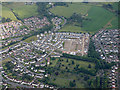
1
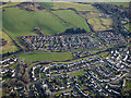
Elderslie from the air
The playing fields at Glenpatrick Road are in the centre.
Image: © Thomas Nugent
Taken: 11 Feb 2019
0.10 miles
2
Green Triangle
Wallace Avenue Elderslie, the monument to William Wallace is situated at the bottom of the avenue. Elderslie is reputed to be the birthplace of William Wallace.
Image: © Chris Court
Taken: 10 Oct 2005
0.10 miles
3
Building site on Abbey Road from the air
See the scene over the past few months...
March 2015 Image
March 2017 Image
April 2017 Image
June 2017 Image
August 2017 Image
April 2018 Image
May 2018 Image
September 2018 Image
Image: © Thomas Nugent
Taken: 28 Jan 2019
0.13 miles
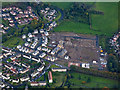
4
Park Avenue
Near the Wallace Monument.
Image: © Thomas Nugent
Taken: 29 Apr 2011
0.14 miles
5
Building site on Abbey Road from the air
Abbey Cemetery is in the foreground.
See the scene over the past few months...
March 2015 Image
March 2017 Image
April 2017 Image
June 2017 Image
August 2017 Image
April 2018 Image
May 2018 Image
September 2018 Image
January 2019 Image
April 2019 Image
February 2019 Image
Image: © Thomas Nugent
Taken: 15 Jul 2019
0.14 miles
6

Elderslie from the air
The building site is at Abbey Road.
See the scene over the past few months...
March 2015 Image
March 2017 Image
April 2017 Image
June 2017 Image
August 2017 Image
Image: © Thomas Nugent
Taken: 16 Apr 2018
0.14 miles
7
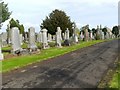
Abbey Cemetery
This photograph was taken from more or less the same point as Image
Image: © Lairich Rig
Taken: 7 Oct 2010
0.14 miles
8
Building site on Abbey Road from the air
See the scene over the past few months...
March 2015 Image
March 2017 Image
April 2017 Image
June 2017 Image
August 2017 Image
April 2018 Image
May 2018 Image
Image: © Thomas Nugent
Taken: 24 Sep 2018
0.14 miles
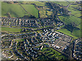
9
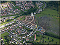
Elderslie from the air
Abbey Cemetery is in the lower right corner. The building site is at Abbey Road.
Image: © Thomas Nugent
Taken: 7 Aug 2017
0.15 miles
10
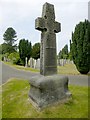
Memorial to Sir Charles Bine Renshaw
An interesting feature of this monument is that, as explained on the base, "this memorial is a restored copy of the ancient cross of Barochan without the historical figures".
(By coincidence, I had viewed Image itself a little earlier on the same day, though I did not photograph it on that occasion. It used to be located at Barrochan Mill, near Houston, before being moved to a nearby hilltop, and then to its present location, inside Paisley Abbey; see the link just cited for a picture, and for further details.)
The memorial in the present photograph is "sacred to the memory of Sir Charles Bine Renshaw of Barochan, Baronet, born Dec 9th 1848, died Mar 6th 1918, and his wife, Dame Mary Home, born Nov 9th 1852, died Feb 13th 1987".
Charles Bine Renshaw was a manufacturer with Messrs A F Stoddard & Co of the Glenpatrick Carpet Works, Elderslie. He married Mr A F Stoddard's daughter, and later became the chairman of the company. He was also a Member of Parliament, and he became the chairman of the Caledonian Railway Company.
Image: © Lairich Rig
Taken: 22 Jul 2013
0.15 miles